Water Security is National Security

Water resources and how they are managed impact almost all aspects of society and the economy, in particular health, food production and security, domestic water supply and sanitation, energy, industry, and the functioning of ecosystems. Under present climate variability, water stress is already high, particularly in many developing countries, and climate change adds even more urgency for action. Without improved water resources management, the progress towards poverty reduction targets, the Millennium Development Goals, and sustainable development in all its economic, social and environ- mental dimensions, will be jeopardized. UN Water.Org

Saturday, January 24, 2015

Drought sees Rio's main hydro plant turned off

Rio de Janeiro (AFP) - A major Rio hydroelectric power plant was switched off after water levels slipped below an operational minimum following severe drought, Brazil's national grid told AFP on Thursday.

Water levels are also dwindling at three other plants that serve a region home to 16 million people, but an ONS spokesman denied there was any immediate threat to energy supplies.

"The hydroelectric plant was switched off Wednesday as there was no longer enough water to keep its turbines turning," the spokesman said of the shutdown at the largest of the four sites.

Rio is laboring under weeks of scant rainfall as stifling temperatures approach 40 degrees Celsius (104 Fahrenheit).

The plants receive their water from the Paraiba do Sul river, which flows through the states of Sao Paulo and Minas Gerais, as well as Rio.

Last month, the states' governors agreed to begin work on improving the infrastructure of the sites as the drought shows little sign of abating.

Last year, Sao Paulo, Brazil's most populous state, suffered its worst drought in 80 years. More


Sunday, January 11, 2015

Egypt refuses Renaissance Dam storage capacity

Egypt rejected the current the Grand Ethiopian Renaissance Dam’s (GERD) high storage capacity, as studies showed it will affect its national water security

Grand Ethiopian Renaissance Dam’

Egypt rejected the current the Grand Ethiopian Renaissance Dam’s (GERD) high storage capacity, as studies showed it will affect its national water security, reported state-owned Middle East News Agency (MENA) Sunday.

The dam’s storage capacity reaches 74bn cubic meters. Calling such capacity “unjustified and technically unacceptable”, Egypt asked Ethiopia to reduce it to what was agreed before the start of negotiations over the years-of-filling and operation of the dam.

Egypt, Ethiopia, and Sudan, the three countries involved, are facing difficulties in technical negotiations, said Alaa Yassin, Advisor to the Egyptian Minister of Water Resources and Irrigation and spokesman for the GERD file, according to state news agency MENA.

Yassin hopes that all parties adhere to the August agreements that took place in Sudan“without procrastination and time-wasting”, while the three countries are trying to overcome these difficulties.

“Egypt’s share in the historic Nile River water red line cannot be crossed,” Yassin told MENA.

Ethiopia began constructing the dam in 2011, and since then Egypt and Ethiopia have been locked in a diplomatic dispute, which reached a peak in 2013. Egypt, which utilises more Nile water than any other country, fears the dispute will have a detrimental effect on its share of Nile water.

As per agreements signed in 1929 and 1959, Egypt annually receives 55.5bn cubic metres of the estimated total 84bn cubic metres of Nile water produced each year, with Sudan receiving 18.5bn cubic metres. More


Thursday, January 8, 2015

LA Imports Nearly 85 Percent of Its Water—Can It Change That by Gathering Rain?

The urban drainage-ways of Los Angeles can never quite look like wild creeks, but restoring some of their capacity to store, slow, and filter water fixes many problems at once.

Walk the glaring streets of Los Angeles’ San Fernando Valley on a sun-soaked afternoon in a drought year, the dry, brush-covered mountains rising behind you, and it can be easy to feel that you’re in arid country. “Beneath this building, beneath every street, there’s a desert,” said the fictional mayor in the Oscar-winning 1974 movie Chinatown. “Without water the dust will rise up and cover us as though we’d never existed!”

It’s an apocryphal idea. L.A. is not the Mojave but, climatically, more like Athens. Artesian springs, fed by rain in the mountains and hills, used to bubble up around Los Angeles, and farmers and Spanish missionaries grew fruit and olives in the Valley starting in the 18th and 19th centuries.

But the city has a history of treating its own raindrops and rivers as if they were more problematic than valuable. The L.A. River was prone to catastrophic floods in heavy rains, and, in the 20th century, engineers buried, straightened, and paved sections of the riverbed, flushing the water through concrete drainage channels to the Pacific Ocean. Then, to quench the thirst of its growing population, Los Angeles undertook a series of engineering feats that pumped water from the eastern Sierra Nevada Mountains, Northern California, and the Colorado River via hundreds of miles of pipes and reservoirs. Now the city typically imports more than 85 percent of its water from afar. And it’s as if the waters of Los Angeles disappeared from the consciousness of locals: Many Angelenos will tell you, mistakenly, that they live in a desert.

Now that story is changing again.

In the past decade and a half, a few local environmentalists have been collaborating with city and county officials to rewrite the plan for water here, driven by more and more urgent necessity. As winter temperatures rise in an era of climate change, the city’s distant water sources, fed by mountain snowmelt, are becoming less reliable. And drought years and battles over water allocation are adding to the difficulties. The State Water Project, which transfers water from the north to southern California, announced this year it would supply only five percent of the amount of water requested by agencies around the state (including the Metropolitan Water District of Southern California, which supplies parts of Los Angeles), because of the drought. Court rulings to protect endangered species have limited the amount of water L.A. and other cities can take from the Sacramento-San Joaquin Delta.

There’s no easy way for L.A. to get more water from distant sources, but new research from UCLA suggests that rainfall in the Los Angeles region is likely to stay the same on average in decades ahead.

Urban drainage in L.A. can never look like wild creeks, but restoring some capacity to store, slow, and filter water fixes many problems.

The city will need to become more water self-reliant to survive the rest of this century, and capturing local rain looks much more desirable than in the past. “There’s been a refocus on the value of local stormwater as a resource, not as a nuisance,” says Kerjon Lee, public affairs manager for the Los Angeles County Department of Public Works.

During the 1990s, in the flat landscape of Sun Valley, a San Fernando Valley neighborhood at the foot of the Verdugo Mountains, Los Angeles engineers and bureaucrats began re-imagining what one could do with raindrops.

Sun Valley never stopped acting as a tributary of the Los Angeles River, even as many of its lots filled, over the past several decades, with sand and gravel pits, auto body shops, junkyards, metals recycling plants, and miscellaneous blue-collar industries. Now two-thirds of the land here is covered with what engineers call an “impervious surface,” like concrete or asphalt, which water cannot penetrate. The more such surfaces there are in a neighborhood, the more rainwater tends to puddle up and flood. Heavy rain can make many of Sun Valley’s streets impassable. In one of the worst storms, about a decade ago, a sinkhole swallowed up part of a major street that used to be a riverbed, and a city engineer tumbled in and died.

Sun Valley is one of a few areas of L.A. not served by the massive drainage system that sends stormwater either to San Pedro or Santa Monica Bay. In the 1990s, the county planned to build a series of storm drains throughout the neighborhood—until a local environmentalist and gadfly named Andy Lipkis stepped in and asked them to reconsider.

Lipkis founded an organization called TreePeople in the mid-1970s, when he was just a teenager. The organization eventually made its headquarters on the site of an old fire station in Coldwater Canyon Park, on the high ridgeline along Mulholland Drive, named after the famous engineer who designed the first system to import water to the city on a large scale. There, among the breezy, fragrant slopes of oak and bay trees, you can see what Lipkis has been trying to tell locals his whole life: Much of Los Angeles is part forest and part river.

In 1998, Lipkis rigged a south L.A. house with water cisterns and rain gardens, gathered a group of local officials, and staged a deluge, aiming fire hoses at the roof. The group watched with amazement as the lot soaked up thousands of gallons of water.

He convinced them to consider what, at the time, was a more experimental and costly approach to managing water in Sun Valley, which overlies the San Fernando Valley Groundwater Basin, an aquifer that supplies about 13 percent of L.A.’s water. Lipkis argued that the county and city could begin to revive some of the features of a natural watershed. The urban drainage-ways of Los Angeles can never quite look like wild creeks, but restoring some of their capacity to store, slow, and filter water fixes many problems at once. When stormwater gushes across pavement, it picks up debris and contamination; when it soaks into soil and enters an aquifer, it is cleaner. Conventional storm drains would have only cost about $40 million, while TreePeople says its recommendations were nearly five times as expensive. But the organization’s own analysis suggested that the latter would return at least $300 million in benefits to the city.

“There’s been a refocus on the value of local stormwater as a resource, not as a nuisance.”

Water managers brought the options to stakeholders and residents in the mostly Latino, working-class neighborhood. They chose Lipkis’ approach. “The community didn’t want more concrete,” says Lee.

Alicia Gonzales moved to Sun Valley in 1985, as a nine-year-old, after her parents “fell in love with the house” on Elmer Avenue. Then she and her family watched as the rains poured through her yard, turning it from grass to mud. She remembers how the rain would form a torrent in the alley near her family’s house. “Trash and shopping carts would get stuck there,” she says.

She moved out as a young adult, then returned several years ago to help her father, who was struggling with severe diabetes and kidney disease and needed regular dialysis.

When the streets flooded, many kids in the neighborhood stayed home. Gonzales often wouldn’t drive her daughters to school on rainy days. “My car would get stuck,” she said.

Though Lipkis had sowed the ideas for a new way to manage water here, years passed before anyone found the funding and wherewithal to solve Elmer Avenue’s flooding problems. In 2004, L.A. County finalized a new stormwater plan for Sun Valley. Two years later, the county finished its first project. Under a baseball and soccer field in Sun Valley Park, a tree-lined oasis in the middle of an industrial district, engineers installed a retention tank that collects runoff from the surrounding streets. In 2007, the county Flood Control District spent nearly $4 million to build drains, catch basins, and a tiny corner park at an intersection that used to turn into a deep lagoon in heavy rain—and was a favorite location for news crews to shoot dramatic footage of local storms.

About eight years ago, employees of TreePeople appeared on Gonzales’ block. They said that her street was part of a watershed, and stormwater from the mountains was pouring into her backyard. (When Gonzales first met Andy Lipkis, she says he rhapsodized about her parents’ olive tree, nearly the only landscaping that had survived the flood damage.) An organization called the Council for Watershed Health had partnered with TreePeople to renovate her street.

“There’s been a refocus on the value of local stormwater as a resource, not as a nuisance.”

The Council for Watershed Health led the effort to pull apart the street and put in rain barrels, rain gardens, underground water tanks, and water-permeable walkways and driveways. Gonzales got one of a few special grants to replant her muddy yard, and volunteers showed up at her house to help with the landscaping. The alley became a pedestrian walkway that the project organizers dubbed The Paseo, a meandering sidewalk lined with native plants between concrete-block walls, painted with the words, “Water is the driving force of life.” In rainstorms now, the water runs through the landscaping, and kids walk the path to school. Neighbors water their drought-tolerant plants with rain barrels, but most of the rain soaks in under the street.

As small as these three projects were—a single city block, a corner park, and a soccer field—they have gotten the attention of the entire region: two Southern California regional water districts, several Los Angeles city and county agencies, the federal Bureau of Reclamation, and a number of state agencies got involved and provided funding for Elmer Avenue. These projects have become test cases for a much larger strategy to boost the water supply every time it rains across the entire region.

In Sun Valley, the county plans ultimately to capture nearly all of the rainwater that pours through the neighborhood. Next to Sun Valley Park, the city and county are planning to convert what is now a gravel pit and concrete plant into a 46-acre park that will collect in an average year about enough water to supply 4,000 Angelenos.

Their findings come at a crucial time. Crumbling infrastructure and a new court ruling are forcing the hands of local officials: A federal court has ordered the county to clean up the Los Angeles and San Gabriel Rivers, currently fouled by the dirt, grime, and toxins that wash from streets into storm drains. Meanwhile, billions of dollars worth of city water infrastructure is falling apart and has to be replaced before it breaks down.

The city of Santa Monica has set a goal to use only local water by 2020.

The city needs to both clean up its stormwater problem and find more water to drink. TreePeople says it could do both at once and is working with the City of Los Angeles to rewrite its entire stormwater management plan by next year. The county has undertaken a study, in partnership with the Bureau of Reclamation, to predict how climate change will affect local hydrology and what it can do to better capture stormwater. Water districts throughout the region are following suit: The Water Replenishment District of Southern California, which manages groundwater for parts of the region, has set a goal to wean itself off imported water altogether by treating and recycling wastewater and collecting more stormwater. The Council for Watershed Health released a study in 2012 estimating that the district could capture 5.5 billion gallons of water per year through more projects like Elmer Avenue.

The city of Santa Monica has set a goal to use only local water by 2020. The Los Angeles Department of Water and Power estimates that by 2035, it will import just over half of its water (down from 85 percent), meet 9 percent of its water needs by conserving more, and supply 28 percent by using local groundwater, capturing stormwater, and recycling water from sewage. Water recycling and stormwater projects aren’t cheap, but they’re typically less costly than building high-energy desalination plants that distill water from the ocean. A new desalination plant is going up in Carlsbad, south of Los Angeles. But if groups like TreePeople and the Council succeed, southern California may not need to build many more facilities like this.

“We’re looking at how we could shift the amount of water we currently squander.” says Edith de Guzman, a researcher at TreePeople. More

Madeline Ostrander wrote this article for Cities Are Now, the Winter 2015 issue of YES! Magazine. Ostrander is a contributing editor to YES! and a 2014 National Health Journalism Fellow. She lives in Seattle and writes about the environment and climate change.


Sunday, January 4, 2015

Abu Dhabi summit to discuss water security challenges

More than 32,000 global leaders from 170 countries representing government, industry, investment and research to Abu Dhabi, will provide an upfront look at affordable technologies to enable sustainable water resource management to help meet the Middle East’s rising demand for water.

Hosted by Masdar, Abu Dhabi’s renewable energy company, ADSW is a yearly platform that addresses the interconnected challenges of energy and water security, climate risk and sustainable development.

Running from January 17 to 24, ADSW includes the World Future Energy Summit (WFES), the world’s foremost event dedicated to the advancement of renewable energy, energy efficiency and clean technology; and the International Water Summit (IWS), which provides a business approach to addressing water scarcity, sustainable growth and economic development in arid regions.

“The Mena region is in a truly unique position to solve the challenge of water security,” remarked Raed Bkayrat, vice president of development for Saudi Arabia at First Solar, which is participating in WFES.

“While the region is quite arid, it also has one of the highest solar irradiances of any region in the world, and much of the population has ready access to seawater. Accordingly, solar photovoltaic projects are proving to be sustainable means of powering water desalination in the region, ensuring that the supply of clean water will keep up with the region’s increasing demand for it,” he noted.

Masdar took a major step by launching a pilot project to test energy-efficient desalination technologies – such as reverse osmosis and forward osmosis – powered by renewable energy.

The company awarded contracts to Abengoa, Degremont, Sidem/Veolia and Trevi Systems to build the desalination plants, which are expected to enable the implementation of cost-competitive desalination plants powered by renewable energy in the UAE and abroad.

“Engaging different sectors of the industry is really crucial to bring forward innovative solutions, as well as pilot projects that demonstrate to governments the value of new integrated systems,” Bkayrat added.

Both WFES and IWS will offer numerous keynote addresses, panel discussions and workshops as well as exhibitors introducing affordable technologies to enable sustainable water resource management.

Along with WFES and IWS, ADSW will include the second EcoWaste and the seventh Zayed Future Energy Prize Award Ceremony; it also coincides with the Fifth General Assembly of the International Renewable Energy Agency.-TradeArabia News Service More


Friday, January 2, 2015

A New Canal Through Central America Could Have Devastating Consequences

When construction crews begin digging a new canal this month across Nicaragua, connecting the Pacific and Atlantic, it’ll be a boon to global shipping and, the government says, to the economy of the second-poorest nation in the Americas.

But activists, scientists and others are increasingly alarmed by the environmental impact of a 173-mile artificial waterway—wider, deeper and three and a half times the length of the Panama Canal.

Developed by Wang Jing, an enigmatic Chinese industrialist with ties to China’s ruling party, the Grand Nicaragua Canal will cost an estimated $40 billion and take five years to build. At 90 feet deep and 1,706 feet across at its widest, the channel will accommodate the newest cargo supertankers, which are longer than the Empire State Building is tall and carry 18,000 shipping containers. The vessels are too big to pass through the Panama Canal (even after a $5 billion expansion is completed) or to dock in any U.S. port.

The new canal and its infrastructure, from roads to pipelines to power plants, will destroy or alter nearly one million acres of rainforest and wetlands. And that doesn’t include Lake Nicaragua, a beloved 3,191-square-mile inland reservoir that provides most Nicaraguans with drinking water. The canal cuts through the lake, and critics say ship traffic will pollute the water with industrial chemicals and introduce destructive invasive plants and animals.

Plus, the canal route lies in the middle of a hurricane belt, says Robert Stallard, a research hydrologist with the U.S. Geological Survey and the Smithsonian Tropical Research Institute. “You’re likely going to be looking at hurricanes vastly more powerful than anything that ever hit Panama, and ever will,” Stallard says. A storm like Hurricane Mitch, which killed 3,800 people in Nicaragua in 1998, would probably cause the canal to flood, triggering mudslides that would breach locks and dams. Communities, homes, roads and power lines would be swamped.

The Nicaraguan government has yet to release promised analyses of the canal’s likely environmental impacts, and has even dodged neighboring Costa Rica’s request to share disaster plans. “We’ve got a lack of information and a potentially big threat to the environment,” says Jorge A. Huete-Pérez, vice president of the Academy of Sciences of Nicaragua. “The government just wants to rush the thing through.” The canal’s true benefits can’t be calculated, Huete-Pérez and others argue, as long as the costs to Nicaragua’s forests, waterways and wildlife remain hidden. More


Thursday, January 1, 2015

Behind the veil of the Islamic State is a war for water

A little known fact of the war in Syria is that it started at the end of the worst drought in Syrian history, a biblical drought which forced over 1 million farmers into the cities.

Pulitzer Prize-winner Thomas L. Friedman interviewed Syrian refugees and farmers in Syria about the link between this drought and the start of the civil war. He comes to the conclusion that the drought certainly played some role and was probably a key tipping point for a bad situation to turn into a full scale war. In the documentary “Years of living dangerously” we see how wiki-leaked diplomatic cables and high level US officials such as Condoleezza Rice acknowledge this link.

But there’s a lot more happening to explain why behind the veil of a quest for an Islamic State (IS), there’s also a war for water in Syria and Iraq. Making the plight of citizens worse is the continued targeting of water supply networks by both regime and opposition forces, which have attacked strategic lifelines, such as water channels, to gain control of territory and to punish and put pressure on their opponents.

Opening the flood gates …

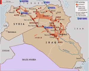
The Islamic State’s quest for hydrological control began in Syria, when it captured the Tabqa Dam in 2013. Rebel-held areas had been systematically denied electricity by President Bashar al-Assad’s forces in their effort to turn the population against the insurgency. The Tabqa Dam was built more than 40 years ago with Russian help and aimed to make Syria self-sufficient in energy production. Behind the dam is Lake Assad, which provides millions of Syrians with drinking water and is a vital irrigation source for farms. After the capture of the dam, IS opened the flood-gates to get maximum electricity supply for the areas they control and win favour with the local population. As a result, the lake dropped six metres, to a record low in May, which worsened the plight of millions of already destitute Syrians as severe water cuts began to hit Aleppo province.

Conflict over the water flowing though the Euphrates and Tigris is of course nothing new and predates religious wars. They were the first rivers to be used for large scale irrigation, in the region once known as the Fertile Crescent. Somewhere between 1720 and 1684 BC, a grandson of Hammurabi dammed the Tigris to prevent the retreat of rebels led by Iluma-Ilum, who declared the independence of Babylon. The Euphrates was already used as a weapon somewhere around 2500 BC, in another fight for Babylon, when the king of Umma cut the banks of irrigation canals alongside the Euphrates dug by his neighbor, the king of Girsu.

The Euphrates and Tigris are the two major and longest rivers in the Middle East. They both originate in Turkey. The Euphrates flows through Syria and Iraq to reach the Persian Gulf while the Tigris flows through Kurdish territory, meeting up with the Euphrates in the Southern Mesopotamian Marshes of Iraq. There are currently at least 46 dams in the Tigris-Euphrates basin, with at least 8 more planned or under construction. These dams have become key pieces of geo-political control in the region.

… and shutting down the flows

While one act of war is opening the flood gates, another is closing them. In 1974, Iraq threatened to bomb the same Tabqa Dam in Syria, alleging that the dam had reduced the flow of Euphrates River water to Iraq. But between then and now, Turkey, through its position upstream, has taken over as the most powerful regional commander of water, by completing the giant Ataturk Dam. In 1990 Syria and Iraq protested that Turkey now has a weapon of war: by closing the gates they could leave them dry. They had good reason to protest. In mid-1990 Turkish president Turgut Özal threatened to restrict water flow to Syria to force it to withdraw support for Kurdish rebels operating in southern Turkey.

In April 2014, the Islamic State blamed the low water levels in Lake Assad to Turkey’s closure of the Ataturk Dam. Sources found by Al Jazeera said that these claims are disputed. But even if the allegations are only partly true: they were used by the Islamic State to issue threats to ‘liberate Istanbul’, if that was necessary. So while Turkey, IS and Assad fight over water, millions of ordinary Syrians and Iraqi’s see their water levels drop dramatically. Not just by a new drought, with rainfall down by 50-85 percent since October 2013, but mostly due to a power struggle.

Tensions over water control in the region are set to heat up further if Turkey completes the Ilisu Dam on the Tigris River near the border of Syria. The Ilisu Dam will generate 1,200 MW and is part of the vast and ambitious Southeastern Anatolia Project, known as GAP after its Turkish title (Guneydogu Anadolu Projesi): a network comprising 22 dams and 19 power plants. The Ilisu reservoir will flood 52 villages and 15 towns, including Hasankeyf, a Kurdish town of 5,500 people, which is the only town in Anatolia that has survived since the Middle Ages and is under archaeological protection. It will displace approximately 16,000 people in the troubled Kurdish region.

The World Bank (WB), the British construction company Balfour Beatty and the Italian company Impreglio have all withdrawn from the problematic project. So have international funds and export credit from Austria, Germany and Switzerland. However, the project is currently funded by Turkish banks. Iraq and also Syria will be the most heavily impacted if the dam and others go through, with the most extreme projections holding that, owing to a combination of climate change and upstream dam activity, the Tigris and Euphrates rivers won’t have sufficient flow to reach the sea by as early as 2040.

If you live in Syria or Iraq and the water irrigating your field stops coming you might join the ranks of any army promising to attack those who kept the water for themselves – no matter if they tell you the truth or not. As is often the case in conflicts or epidemics it is not the facts themselves that count most but what people believe to be the facts. Those who can convince it’s the enemies fault that there’s not enough water will have the key to where the hearts and minds of the people will go to – no matter what the facts are.

The US finally finds a Weapon of Mass Destruction in Iraq

The Tabqa Dam is not the only dam attacked by IS. They are also trying to take the Haditha Dam, the second-largest in Iraq, raising the possibility of catastrophic damage and flooding. On Sunday, the US was bombing IS positions close to the dam. The IS militants are also fighting for control of the Euphrates River Dam, about 120 miles northwest of Baghdad and government forces were fighting to halt their advance. Insurgents from IS seized the Falluja Dam in Iraq in February and closed the floodgates to cause upstream flooding and to cut downstream water supply. Some 40.000 people were displaced just to flood the area around the city of Falluja to force government troops to retreat and lift a siege, while cutting water supplies and hydroelectricity generation for other parts of the country. All that was peanuts compared to what IS did next.

On August 7 IS captured the 1GW Mosul Dam on the Tigris – sending shock waves through Bagdad, Kuwait and the US. Whoever controls the Mosul Dam, the largest in Iraq, controls most of the country’s water and power resources. Located on the Tigris River upstream of Mosul, the dam, 3.6 km long and with 320 MW of capacity daily, formerly known as the Saddam dam, was built beginning in 1980 at a cost of 1.5$ billion USD, to bolster the regime during the Iran-Iraq war by a German-Italian consortium that was led by Hochtief Aktiengesellschaft. Its construction submerged many archaeological sites in the region yet more troubling is that because the dam was constructed on a foundation of soluble gypsum, it requires continuous grouting of the dam’s foundation to promote stability. Due to the engineering problems it presents it has been described recently by US engineers as “the most dangerous dam in the world.” And that was before the “most dangerous terror group ever” captured it.

A senior U.S. administration official said that “The failure of the Mosul Dam could threaten the lives of large numbers of civilians, threaten U.S. personnel and facilities – including the U.S. Embassy in Baghdad – and prevent the Iraqi government from providing critical services to the Iraqi populace,” (Source: Reuters). A 2006 U.S. Army Corps of Engineers report obtained by the Washington Post said the dam, which blocks the Tigris and holds 12 billion cubic meters of water, could flood two cities killing over a half a million people if it were destroyed or collapsed. The tsunami going to Mosul, a city of 1.7 million people, can be 20m high if the dam breaks with a full reservoir.

But even without a catastrophic failure, the dam is already at the epicenter of the war. Soon after the Islamic State captured the Mosul Dam they cut supplies to some villages in the north of the country that have not joined their cause. Recapturing this instrument of war was a sufficient reason for US forced to deploy air power to support Kurdish forces to recapture the dam. Saving the Yazidis from their mountain captured most media attention, but a key reason for the US to bomb Iraqi soil for the first time since 2011 was the fact that IS took the Mosul Dam. After bombing IS positions for several days, freshly re-equipped Kurdish fighters recently regained control of the dam.

Mega Dams & Water Management Practices

The importance of hydro-infrastructure in these battles and how it can be wielded firstly underlines the need for a serious re-appraisal of water management practices. Big dams (with funding from Multilateral agencies such as the WB, national and regional development banks, private equity and pension funds as well as from the Clean Development Mechanism, etc.) cause large scale displacement of populations, are ecologically destructive, wash away any other source of livelihood, and often saddle countries with debt while performing well below planned outputs as regards electricity generation. Moreover, compounded by climate change, contemporary ecological crises are leading to ever more conflict over trans-boundary water rights, such as for example between Ethiopia and Egypt, which are also on the verge of war over the construction of the Grand Renaissance and Gibe 3 dams, which would become Africa’s tallest. The world’s Big Dam Fan Club should take note of what has just happened in Syria and Iraq and realise that once disaster hits, hatred will not go to any God but to those who constructed the weapon of mass destruction. Water, rather than oil, is shaping up to be the key strategic resource in the region. More