Water Security is National Security

Water resources and how they are managed impact almost all aspects of society and the economy, in particular health, food production and security, domestic water supply and sanitation, energy, industry, and the functioning of ecosystems. Under present climate variability, water stress is already high, particularly in many developing countries, and climate change adds even more urgency for action. Without improved water resources management, the progress towards poverty reduction targets, the Millennium Development Goals, and sustainable development in all its economic, social and environ- mental dimensions, will be jeopardized. UN Water.Org

Showing posts with label China. Show all posts

Sunday, November 26, 2017

In Peru's deserts melting glaciers are a godsend - until they are gone

Using some of the glacial water to ‘Green’ the Peruvian the desert, as is being done in China and North Africa would be a smart move. See LOESS PLATEAU WATERSHED REHABILITATION PROJECT


Yet climate change now threatens some of these ambitious undertakings, reducing lakes, diminishing aquifers and shrinking glaciers that feed crops. Here in Peru, the government irrigated the desert and turned it into farmland through an $825 million project that, in a few decades, could be under serious threat.

“We’re talking about the disappearance of frozen water towers that have supported vast populations,” said Jeffrey Bury, a professor at the University of California at Santa Cruz who has spent years studying the effects of glacier melt on Peruvian agriculture. “That is the big picture question related to climate change right now.”

A changing climate has long haunted Peru. One past civilization, the Moche people, built cities in the same deserts, only to collapse more than a millennium ago after the Pacific Ocean warmed, killing fish and causing flash floods, many archaeologists contend.

Now dwindling water is the threat. While more than half of Peru sits in the wet Amazon basin, few of its people ever settled there. Most inhabit the dry northern coast, cut off from most rain by the Andes range. While the region includes the capital, Lima, and 60 percent of Peruvians, it holds only 2 percent of the country’s water supply.

The glaciers are the source of water for much of the coast during Peru’s dry season, which extends from May to September. But the icecap of the Cordillera Blanca, long a supply of water for the Chavimochic irrigation project, has shrunk by 40 percent since 1970 and is retreating at an ever-faster rate. It is currently receding by about 30 feet a year, scientists say. https://goo.gl/Wa1JyK

Friday, January 2, 2015

A New Canal Through Central America Could Have Devastating Consequences

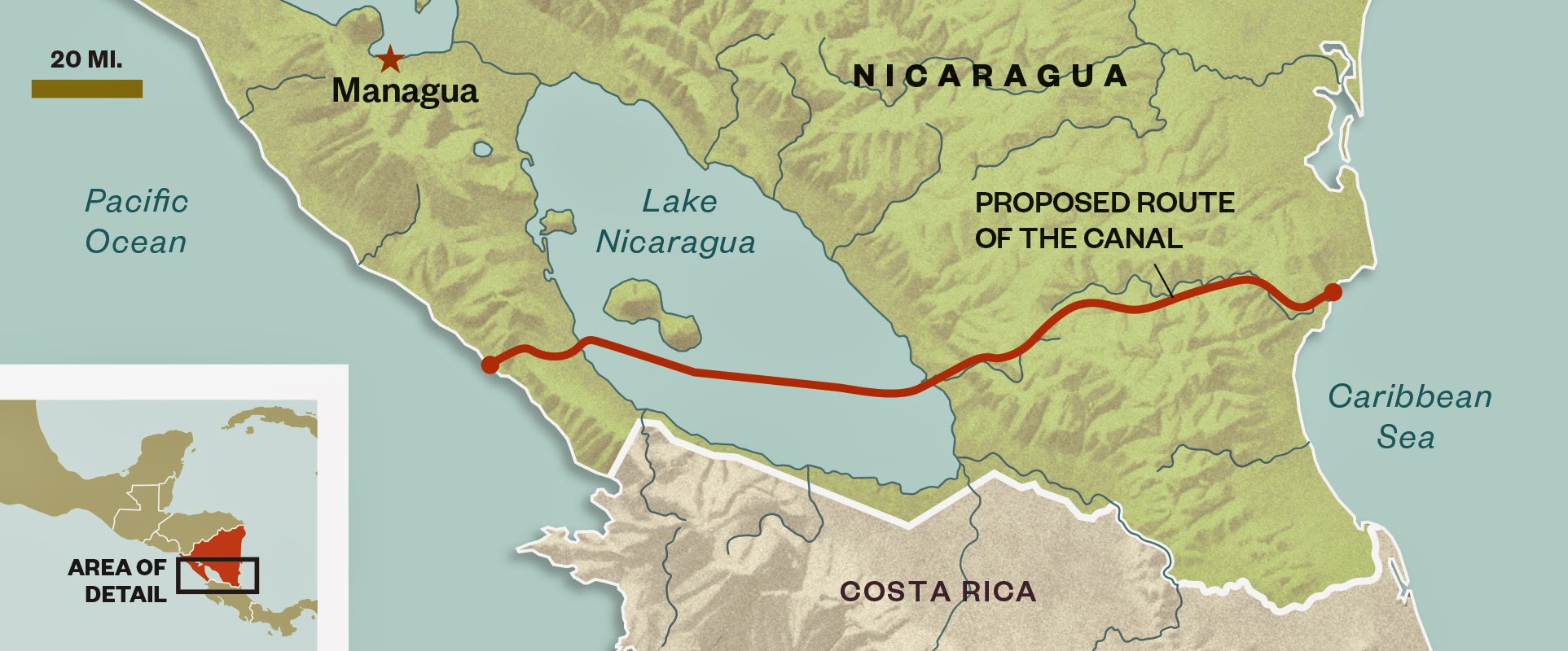
When construction crews begin digging a new canal this month across Nicaragua, connecting the Pacific and Atlantic, it’ll be a boon to global shipping and, the government says, to the economy of the second-poorest nation in the Americas.

But activists, scientists and others are increasingly alarmed by the environmental impact of a 173-mile artificial waterway—wider, deeper and three and a half times the length of the Panama Canal.

Developed by Wang Jing, an enigmatic Chinese industrialist with ties to China’s ruling party, the Grand Nicaragua Canal will cost an estimated $40 billion and take five years to build. At 90 feet deep and 1,706 feet across at its widest, the channel will accommodate the newest cargo supertankers, which are longer than the Empire State Building is tall and carry 18,000 shipping containers. The vessels are too big to pass through the Panama Canal (even after a $5 billion expansion is completed) or to dock in any U.S. port.

The new canal and its infrastructure, from roads to pipelines to power plants, will destroy or alter nearly one million acres of rainforest and wetlands. And that doesn’t include Lake Nicaragua, a beloved 3,191-square-mile inland reservoir that provides most Nicaraguans with drinking water. The canal cuts through the lake, and critics say ship traffic will pollute the water with industrial chemicals and introduce destructive invasive plants and animals.

Plus, the canal route lies in the middle of a hurricane belt, says Robert Stallard, a research hydrologist with the U.S. Geological Survey and the Smithsonian Tropical Research Institute. “You’re likely going to be looking at hurricanes vastly more powerful than anything that ever hit Panama, and ever will,” Stallard says. A storm like Hurricane Mitch, which killed 3,800 people in Nicaragua in 1998, would probably cause the canal to flood, triggering mudslides that would breach locks and dams. Communities, homes, roads and power lines would be swamped.

The Nicaraguan government has yet to release promised analyses of the canal’s likely environmental impacts, and has even dodged neighboring Costa Rica’s request to share disaster plans. “We’ve got a lack of information and a potentially big threat to the environment,” says Jorge A. Huete-Pérez, vice president of the Academy of Sciences of Nicaragua. “The government just wants to rush the thing through.” The canal’s true benefits can’t be calculated, Huete-Pérez and others argue, as long as the costs to Nicaragua’s forests, waterways and wildlife remain hidden. More


Thursday, September 4, 2014

Henan’s Big Drought. Is This From The South–North Water Transfer Project?

Mainland media reported that, since this summer, Henan Province rainfall is 60 percent less than usual over the same period since 1951, which is the lowest value over the same period of history. Pingdingshan City's main water source, Baiguishan reservoir water level is even lower than the dead water of 97.5 meters.

Henan Zhecheng County Shuangmiao Village Ms. Li, “over the entire summer it did not rain. The crops are dry. We are not allowed to irrigate the crops. If I use the well water, I probably cannot even have drinking water."

Droughts have had a serious impact on local agriculture.

Ms. Li, "most places basically have no harvest. Individual crops can be harvested a little, but there is not much. If one place can harvest 40 percent, that’s the best.''

Hubei Province is rich in water during the main flood season this year. But rainfall in most areas decreased by more than 20 percent. 111 small reservoirs and over 50,000 ponds dried up; over 600 reservoirs are below the dead water level; Hanjiang River downstream water level dropped. Danjiangkou reservoir water level is only 142.77 meters on August 19. This is far below the SNWTP planned water level of 170 meters.

For this major disaster, the authorities explained that the drought is caused by a variety of climatic reasons. They claimed that, even if the current trend of precipitation is "north flood south dry", it is still to "transfer water from south to north" to fill the gap of an especially severe water shortage in Beijing.

But the villagers in drought regions have different thoughts.

Ms. Li, " we all think it is due to the SNWTP. In previous years, it was not as dry as in these years."

Villagers discussed and believe that, SNWTP leads the Han River, the Yangtze River and the Yellow River water back and forth; the Three Gorges Reservoir also caused natural flowing rivers to change direction. Poor circulation, and loss of groundwater resources are also very serious. It has a massive impact not only to the surrounding geological environment, but also caused imbalances to the water, clouds, rain, and natural circulation system leading to a severe drought.

Living in Germany, water resources expert Wang Weiluo, has published many articles about Jiang Zemin who to "supply water to the 2008 Beijing Olympics", hastily approved and launched the SNWTP in 2001. It introduced one billion cubic meters of water annually to Beijing, with diversion channels crossing more than 700 natural rivers in Central China. The project completely

broke the law of nature of these rivers; There is a serious engineering problem, even bigger than the Three Gorges, and the threat is to a wider area.

Beijing electrical engineer Mr. Tian, "in principle there is a problem, because it is not that the south is high, the north is low, and it naturally flows across. It is to artificially add a number of processes, which undermines the law of nature. I think this may be even worse than the Three Gorges Dam."

Problems have been reported recently about SNWTP by the media. When the Diversion project tested the water on July 3 for the first time, the media exposed that the water source from Danjiangkou Reservoir exceeded the nitrogen content, and was seriously polluted. The official also acknowledged that water quality for nitrogen and phosphorus exceeded the standards. However he stressed that it would naturally degrade through long-distance transportation.

In late July, the mainland media also reported that SNWTP led to a decrease in the Han River water level. Due to the reduced water flow the fish were unable to spawn by end of July, while in previous years they had finished spawning. Yicheng city located by the Han River was without water three times since last year, the longest time was 48 hours.

In addition to the environmental damages, Beijing electrical engineer Mr. Tian pointed out that the drain from SNWTP is likely to outweigh the benefits.

Mr. Tian, "this unnatural process takes a lot of energy and wastes a lot of water. Introduce ten percent water, and finally arriving in Beijing, maybe even not two percent will get there."

SNWTP has three water diversion routes, namely the east, middle and west line. Of which the middle and east lines cost amounted to 500 billion yuan, 2.5 times larger than the Three Gorges Project. The East line is pumped from the Yangtze River to Tianjin, Qingdao and Yantai direction. The Midline is from Danjiangkou Reservoir as a division of Yangtze tributary the Han River, in Beijing’s direction; The West line is from the upper Yangtze River to the Yellow River water diversion. The East line started in December 2002, until December 8, 2013 the water went through. The Midline started in December 2003, is expected to have water through in October 2014. The West Line has not been started yet. More


Sunday, August 17, 2014

China Suffers Drought, Water Shortage

This summer has been one of the hottest in decades in Jilin Province, China, and several counties are facing the complete loss of their harvests.

Currently, Changling, Nongan, Gongzhuling and 10 other agricultural counties in Jilin are facing a severe drought. The severity of the drought is comparable to that in 1951.

A villager Ms. Lee from Wanglong village, Huajia Township, Nongan County, Changhun City, told Epoch Times: “The drought is very bad. All the corn leaves have turned yellow. Corns are not fully grown, only their tips are seen with barely any kernels.”

Since July 1 this year, the rainfall in Jilin Province totaled only 4.4 inches, which is about 48 percent less compared to the same period from previous years. This year had the second lowest rainfall in history; the least amount since 1951.

Over 14 million acres of farmland are affected.

Government data indicates the drought has impacted more than 1.3 million acres of farmland in the major agricultural areas of Jilin with no improvements in sight. According to the weather forecast, the average rainfall could be as low as a third of an inch per day.

Ms. Lee, a villager from Wanglong village said: “Even the water level of our own well is slowly dropping. It is only enough for domestic use. Our farmland has not been irrigated for over a month.”

Mr. Sun from Zhen-Chai village, Nongan County said that all their cucumber plants have perished from the drought.

Chinese media has reported two-thirds of the corn stalks have withered in some towns while others have completely perished.

Local governments have not taken any measure to tackle this problem and villagers are on their own. A staff member at Jilin Grain Bureau only briefly told Epoch Times that the situation was “unclear” and then hung up the phone.

Other Provinces Impacted

During the summer, a total of 12 provinces, including Shandong, Henan, Shaanxi Anhui, Hubei, Gangsu, and Xinjiang, have been affected by the drought. Over 14 million acres of farmland are affected.

Henan Province, for example, is witnessing the worst drought in the last 63 year with 740,000 people facing a temporary shortage of drinking water. In Shandong Province the cost of the lost harvest is reaching $630 million.

All these statistics put into question the recently announced food exports to Russia. After Russia announced it would stop importing food from Europe, the United States, and Australia, China immediately started building a warehouse on the Russian boarder to facilitate customs clearance for fruit going into Russia. More


Monday, July 14, 2014

The Unity of Water

MOSCOW – In May, Vietnam became the 35th and decisive signatory of the 1997 United Nations Convention on the Law of the Non-Navigational Uses of International Watercourses. As a result, 90 days later, on August 17, the convention will enter into force.

The fact that it took almost 50 years to draft and finally achieve the necessary ratification threshold demonstrates that something is very wrong with the modern system of multilateralism. Regardless of longstanding disagreements over how cross-border freshwater resources should be allocated and managed, and understandable preferences by governments and water professionals to rely on basin agreements rather than on international legal instruments, that half-century wait can be explained only by a lack of political leadership. So, though the world may celebrate the convention’s long-awaited adoption, we cannot rest on our laurels.

Roughly 60% of all freshwater runs within cross-border basins; only an estimated 40% of those basins, however, are governed by some sort of basin agreement. In an increasingly water-stressed world, shared water resources are becoming an instrument of power, fostering competition within and between countries. The struggle for water is heightening political tensions and exacerbating impacts on ecosystems.

But the really bad news is that water consumption is growing faster than population – indeed, in the twentieth century it grew at twice the rate. As a result, several UN agencies forecast that, by 2025, 1.8 billion people will be living in regions stricken with absolute water scarcity, implying a lack of access to adequate quantities for human and environmental uses. Moreover, two-thirds of the world’s population will face water-stress conditions, meaning a scarcity of renewable freshwater.

Without resolute counter-measures, demand for water will overstretch many societies’ adaptive capacities. This could result in massive migration, economic stagnation, destabilization, and violence, posing a new threat to national and international security.

The UN Watercourses Convention must not become just another ignored international agreement, filed away in a drawer. The stakes are too high. In today’s context of climate change, rising demand, population growth, increasing pollution, and overexploited resources, everything must be done to consolidate the legal framework for managing the world’s watersheds. Our environmental security, economic development, and political stability directly depend on it.

The convention will soon apply to all of the cross-border rivers of its signatories’ territories, not just the biggest basins. It will complement the gaps and shortcomings of existing agreements and provide legal coverage to the numerous cross-border rivers that are under increasing pressure.

Worldwide, there are 276 cross-border freshwater basins and about as many cross-border aquifers. Backed by adequate financing, political will, and the engagement of stakeholders, the convention can help address the water challenges that we are all facing. But will it?

An ambitious agenda should be adopted now, at a time when the international community is negotiating the contents of the Sustainable Development Goals (SDGs), the successor to the UN Millennium Development Goals, which will expire in 2015. We at Green Cross hope that the new goals, which are to be achieved by 2030, will include a stand-alone target that addresses water-resources management.

Moreover, the international community will soon have to agree on a climate-change framework to replace the Kyoto Protocol. Climate change directly affects the hydrological cycle, which means that all of the efforts that are undertaken to contain greenhouse-gas emissions will help to stabilize rainfall patterns and mitigate the extreme water events that so many regions are already experiencing.

But the UN Watercourses Convention’s entry into force raises as many new questions as existed in the period before its ratification. What will its implementation mean in practice? How will countries apply its mandates within their borders and in relation to riparian neighbors? How will the American and Asian countries that have largely ignored ratification respond?

Furthermore, how will the convention relate to the Convention on the Protection and Use of Transboundary Watercourses and International Lakes, which is already in force in most European and Central Asian countries and, since February 2013, has aimed to open its membership to the rest of the world? Similarly, how will the convention’s implementation affect existing regional and local cross-border freshwater agreements?

The countries that ratified the UN Watercourses Convention are expected to engage in its implementation and to go further in their efforts to protect and sustainably use their cross-border waters. What instruments, including financial, will the convention provide to them?

Several legal instruments can be implemented jointly and synergistically: the Ramsar Convention on Wetlands, the UN Convention to Combat Desertification, and the UN Framework Convention on Climate Change, to name just a few. The UN Watercourses Convention’s long-delayed enactment should be viewed as an opportunity for signatory states to encourage those that are not yet party to cooperative agreements to work seriously on these issues.

Clearly, politicians and diplomats alone cannot respond effectively to the challenges that the world faces. What the world needs is the engagement of political, business, and civil-society leaders; effective implementation of the UN Watercourses Convention is impossible without it.

This is too often overlooked, but it constitutes the key to the long-term success of cooperation that generates benefits for all. Inclusive participation by stakeholders (including the affected communities), and the development of the capacity to identify, value, and share the benefits of cross-border water resources, should be an integral part of any strategy to achieve effective multilateral collaboration. More


Sunday, June 29, 2014

Himalayan Water Security: The Challenges for South and Southeast Asia

The scramble for control of natural resources to support economic and population growth, combined with the uncertain effects of climate change on the Tibetan Plateau, is raising tensions in Asia over Himalayan water resources.

Ten of the region’s largest and longest rivers (the Amu Darya, Brahmaputra, Ganges, Indus, Irrawaddy, Mekong, Salween, Tarim, Yangtze, and Yellow) originate in the Himalayas. These rivers help provide water, food, and energy for nearly 4 billion people in China and across South and Southeast Asia—nearly half of the world’s population. However, depletion and diversion of these transborder resources to meet growing industrial, agricultural, and urban demands have the potential to trigger far-reaching economic, social, and environmental challenges.

The lack of comprehensive and effective regional frameworks for cooperation hinders sustainable management of these waterways. China, which controls the headwaters of these rivers, has an enormous need for Himalayan water to satisfy economic and energy demands but has little incentive to participate in formal water-sharing and water-management agreements with its neighbors. China’s dam-building and water-diversion projects are a source of major concern to the countries downstream, which often complain about Beijing’s lack of transparency and reluctance to share information. Although managing water-sharing relations with China might be the most prominent challenge, cooperation is not much easier at the middle and lower reaches of the rivers. Collaboration in South and Southeast Asia is frequently frustrated by competing national interests, economic priorities, political disputes, and weak regional organizations. In addition to the environmental impacts of man-made diversion projects and unsustainable freshwater usage, there is also inadequate cooperation on scientific research to understand and prepare for the effects of climate change on the region’s water supplies.

This Asia Policy roundtable contains seven essays that discuss the challenges and implications of water security in Asia and recommend steps that both upstream and downstream countries could take to better manage the region’s shared water resources.

Asia’s Unstable Water Tower: The Politics, Economics, and Ecology of Himalayan Water Projects
Kenneth Pomeranz

China’s Upstream Advantage in the Great Himalayan Watershed
Jennifer L. Turner, Susan Chan Shifflett, and Robert Batten

Melting the Geopolitical Ice in South Asia
Robert G. Wirsing

Himalayan Water Security: A South Asian Perspective
Tushaar Shah and Mark Giordano

Hydropower Dams on the Mekong: Old Dreams, New Dangers
Richard P. Cronin

Climate Change and Water Security in the Himalayan Region
Richard Matthew

Securing the Himalayas as the Water Tower of Asia: An Environmental Perspective
Jayanta Bandyopadhyay

Download PDF


As I have been arguing for a number of years South Asia needs to re-negotiate the Indus Water Treaty to encompass Afghainstan, Bangladesh, Bhutan, China, India, Nepal and Pakistan before the region starts to suffer from water insecurity and the effects of climate change. Editor


Sunday, March 23, 2014

How NASA Can Save Us Billions of Gallons of Water

Here’s something to add to your doomsday list of natural resources that people need to survive but are threatened by climate change: snow.

It’s a key source of freshwater for more than 1 billion people across the globe, slaking thirst, irrigating croplands, and driving turbines that generate electricity. Conveniently, in much of the world, snow also acts as a natural reservoir, storing water during wet seasons, then rationing it out slowly during drier summer months. But today, growing populations, warming temperatures, and changing weather patterns are straining that supply like never before. “June is the new July,” says Auden Schendler, vice president of sustainability at Aspen Skiing Company in Colorado. “Snowmelt comes earlier than it used to, and it all happens in one big flood.”

Which means that knowing exactly how much snow is in the highlands—and when it’s coming down to lower elevations to feed rivers, aqueducts, and irrigation channels—is ever more important. But how do you measure something that’s spread over thousands of miles of steep, rugged, alpine terrain?

Tom Painter, a research scientist at NASA’s Jet Propulsion Laboratory, has an answer: by measuring snow from thousands of feet in the air. Using sophisticated, aircraft-borne sensors that gauge snow’s depth and the amount of light it reflects, Painter and his team are assembling the most accurate measurement ever made of just how much water the mountains hold.

This is welcome news in California, where the water content of accumulated snow is at historically low levels. Runoff from the Sierra Nevada mountains provides about a third of the entire state’s water, and up to 80 percent in some areas, supplying tens of millions of people and almost 1 million acres of farmland.

Painter can’t make it snow, but he can provide more and better data to water managers, who need to plan how to most efficiently fill their reservoirs; farmers deciding which crops to plant and when; and cities trying to figure out if they’ll have enough water to supply their residents—or will need to start rationing. “The demand for knowledge about water resources is at an all-time high,” says Painter, a gregarious, athletically built 46-year-old.

For decades, state water officials have estimated the snowpack’s water content by a straightforward method that will appeal to steampunk aficionados: They clamber into the mountains on snowshoes and stick aluminum tubes into the snow. The tubes indicate depth while collecting a sample revealing water volume. More recently, California has added a network of tabletop-size scales scattered through the mountains that electronically transmit the weight of snow that has fallen on them.

Both systems yield reliable measurements but only of the snow where the measurement is taken; extrapolating out from that to a whole basin, or a whole mountain range, is better than guesswork but less than precise. What’s more, both the scales and the human surveyors are concentrated at lower elevations, leaving scientists to wonder what lies farther uphill. “The old system worked OK historically because there was always enough water,” says Painter. “But now it’s all been allocated out, and demand is starting to exceed supply.” More


Thursday, March 6, 2014

China is so bad at conservation that it had to launch the most impressive water-pipeline project ever

BEIJING—On a Saturday morning in late August, about a dozen university students, professors, and middle-aged Beijing locals stand by a row of apartments in northwestern Beijing. Once an outskirt of the city known for its natural springs and reed-filled ponds, the area now looks just like another part of the sprawling capital: wide roads lined with set-back buildings, crowded with pedestrians. It’s home to some of China’s best schools, Peking and Tsinghua universities. One member of the group—an environmental society called the Green Earth Volunteers, led by one of China’s most well-known environmentalists, Wang Yongchen—asks a local if he knows how to get to the Wanquan River.

“That’s a river?” the man asks, and offers directions to what he says is a nearby ditch that sometimes puddles. After a few minutes, the Green Earth Volunteers arrive at a narrow canal holding a few centimeters of water. The bed of the Wanquan, which means “ten thousand springs,” is now paved over with concrete, the result of attempts to keep water from soaking into the ground when the canal was full. A pipe, once used to carry water into the small river, lies exposed to the sun, as do patches of dry ground. Ivy creeps along the sides of the canal, as if trying to reach what’s left of the water.

The Wanquan is one of thousands of rivers in China that have dried and disappeared after decades of declining rainfall, prolonged droughts, exploding population growth, industrial expansion, and a series of disastrous reservoirs built during the early days of the Communist Republic. The problem is most obvious in Beijing, which was chosen to be China’s capital in part because of its abundance of streams and freshwater springs. Beijing consumed 3.6 billion cubic meters (127 billion cubic feet or 950 billion gallons) of water in 2012, far more than the 2.1 billion cubic meters per year the city has at its disposal in nearby rivers and in the ground. The city’s water resources, about 120 cubic meters per person a year, are well below the 500 cubic meters the UN deems a situation of “absolute water scarcity.” Beijing has been supplementing the shortfall by diverting water from the nearby province of Hebei and trying to lower water usage in the city.

China’s water crisis

China has a severe water problem overall. Its resources of freshwater, around2,000 cubic meters per capita, are one-third of the global average. Coal production, which supplies about three-quarters of China’s energy, already accounts forone-sixth (pdf, p. 3) of total water withdrawals. Between now and 2040 China’s total energy demand is expected to more than double, and be twice that of the US(slide 26). The World Bank has put the annual cost of China’s water problems—specifically, water scarcity and the direct impacts of water pollution—at 2.3% of GDP (pdf, p. xxi) but says it is likely much higher. About 45% of the country’s GDPcomes from water-scarce provinces, according to a 2012 report by HSBC and China Water Risk, a consultancy. About 300 million people in China, almost a quarter of its population, drink contaminated water every day. Former Chinese premier Wen Jiabao wasn’t being dramatic in 1999 when he called the country’s water problems a threat to the “survival of the Chinese nation.”

But these shortages are unevenly spread. The North Plain, a region home to a quarter of the population, and which includes Beijing, is especially dry. Here, water tables are falling by two to three meters a year (pdf, p. 194), according to the UN, and posing serious risks to agriculture and food security. Of China’s 22 provinces, 11 were considered “water-stressed,” meaning they have less than 1,000 cubic meters of water per person a year as of 2012. One of the north’s main water sources, the Yellow River, has been shrinking for the past three decades, drying up almost every year before reaching the the sea. Hebei province, which neighbors Beijing, has seen 969 of its 1,052 lakes dry up; some of its farmers water their crops with sewage water. Wang Shucheng, a former minister of water resources, predicted that if groundwater extraction in the north continues at current rates, in 15 years there will be none left.

The solution, as Mao Zedong first said in 1952, is to “borrow a little water from the south.” Southern China is home to four-fifths of the country’s water sources, mostly around the Yangtze River Basin. It took another 50 years after Mao’s suggestion for China to start work on it. Finally, on Dec. 10, the first phase of the South-to-North Water Diversion Project (SNWDP) or Nanshuibeidiao, began operating.

The project’s eventual goal is to move 44.8 billion cubic meters of water across the country every year, more than there is in the River Thames. The infrastructure includes some of the longest canals in the world; pipelines that weave underneath riverbeds; a giant aqueduct; and pumping stations powerful enough to fill Olympic-sized pools in minutes. It is the world’s largest water-transfer project, unprecedented both in the volume of water to be transferred and the distance to be traveled—a total of 4,350 km (2,700 miles), about the distance between the two coasts of America. The US, Israel, and South Africa are home to long-distance water transfer systems, but none on this scale.

It’s the kind of operation, observers of China say, that would never have a chance somewhere like America. The project requires the coordination of at least 15 provinces—several of them water-rich areas that will have to give up some of their own water. It involves building over hundreds of archeological sites and eventually through religious ones as well. Almost half a million people will have to be relocated. The cost is budgeted at some $60 billion and is likely to exceed that considerably. In the US, proposals for large-scale water transfers from the Great Lakes to the west or south of the country have been repeatedly put down. It would seem to be an example of the power of an autocratic central government to enact the kinds of far-reaching national transformations that, in a democracy, get bogged down.

But a closer look reveals that it’s far from certain whether the benefits will outweigh costs: Some describe the project as a “high-risk gamble.” And rather than showing off the power of China’s central government, in many ways the project merely highlights the limitations of the central government’s ability to manage China’s water needs.

Three horizontals, four verticals

The project creates a grid of water highways that criss-cross the country and can be adjusted to send water almost anywhere. That grid—the siheng sanzong, literally the “four horizontals, three verticals”—consists of the Yangtze, Yellow, Huai, and Hai Rivers running west to east, and three routes that run from south to north, each longer than 1,500 kilometers (600 miles) through both natural and man-made canals.

The first branch, the eastern route, has just started transferring water from the Yangtze River in Jiangsu province to the dry cities in Shandong province. A second route will start carrying water from central China to Beijing and other northern cities at some point in 2014. The third, western route may link the Yangtze River to the Yellow River by crossing through the mountainous terrain of Sichuan and Qinghai, at elevation of between 3,000 and 5,000 meters.

Borrowing water from the south isn’t as simple as Mao suggested. The government has so far relocated at least 345,000 people to make way for construction, the largest resettlement for an infrastructure project since at least 1.4 million people were moved for the Three Gorges Dam. Officials say their relocation is a sacrifice for the good of the country, but others argue that the government is overlooking the extent and impact of the forced relocations that are taking place. The diversion project also risks long-term damage to two of China’s most important rivers, along with the communities that depend on them.

Less water upstream, and more pollution

About 1,400 kilometers south of Beijing and its dried-up Wanquan River is the ancient town of Xiangyang, best known as the setting for epic battles over control of southern China over 700 years ago. Today, stretches of newly paved highways dotted with half-built high-rise apartment buildings lead to the city of 5 million. Locals brag that their strip of the Han River has some of the best water in the country. Of China’s six levels of water quality, theirs is of the second highest level, crisp and clean enough for drinking—a rarity in a country where as many as 20% of rivers are so polluted they’re unsafe to even touch. Over the summer, traffic near the river shore jams around 6pm as people stream to the water for a quick bathe before dinner.

That may change once the central route of the water transfer system opens next year. About 30% of the Danjiangkou Reservoir will then go north instead of flowing south toward Xiangyang and into the Yangtze River—the river that supplies water to the diversion project’s eastern route, and eventually the western one as well. Officials say any impact will be minimal, but local environmentalists and researchers dispute that. Worse, some say, is that diverting this much water may permanently hurt two of China’s most important rivers: the Han, the main source of water for about 30 million people, and the Yangtze, which runs through 11 provinces and supports up to 400 million people.

“We’ve resolved a lot of issues and done a lot of research. The negative impacts are so small they almost don’t exist,” says Shen Fengsheng, head engineer of the water project, sitting at a broad wooden table at the SNWDP’s project office in Beijing. When all three routes are completed, he says, the Yangtze will lose only about 5% of the 29,400 cubic meters of water it dumps into the ocean every second.

Local governments are building passageways for fish whose routes are disrupted by the canals, supplementary dams to ensure consistent water flow, and wastewater treatment plants to reduce pollution in water transferred or affected by the central or eastern routes. Officials in charge of managing the diversion from Danjiangkou say they’re making sure a minimum amount of water still flows downstream to cities like Xiangyang. ”The water volume overall will be lower, but it will be enough to meet the daily needs of the people,” Zhou Jinhua, general office director at Danjiangkou SNWDP Water Resources Company, in charge of the dam for the Danjiangkou Reservoir, told Quartz.

Locals in Xiangyang, however, say their water will become not only more sparse but also more polluted. Water quality there will fall at least one level when the route begins, according to Yun Jianli, head of Green Hanjiang, a nonprofit environmental group based in Xiangyang. That’s because decreasing water volume weakens a river’s “environmental capacity”—its ability to clear out pollution. Provincial researchers say the quality will go down another level, to the fourth of six, once the central route is at full capacity.

A slower-flowing river is also slower at depositing the sediments along the riverbed needed to form wetlands, which help mitigate pollution and nurture the river’s ecosystem. According to estimates by the Xiangyang municipal government, average water levels in the city’s section of the Han River will fall between0.51 meters and 0.82 meters (pdf) once diversion begins. “That water quality level will be worse is a foregone conclusion. The situation for the water environment is grim,” says a provincial report on the impact of the project on the Han River near Xiangyang, which was seen by Quartz.

“You haven’t even fixed the old problem, and you’ve already created new problems.”

In part to prepare for the diversion, Xiangyang is transforming itself. Plots of land covered in brick and concrete rubble litter the city as officials tear down paper and chemical factories. These have long been a large part of Xiangyang’s economy; now local officials want to move the economy away from manufacturing to minimize pollution in the Han River, and build up a services sector based on things like tourism. But as part of doing so, they plan to expand the city to three or four times its current size. Given that city dwellers consume about three times as much water as rural residents, according to International Rivers, a US-based environmental group, a bigger Xiangyang will probably guzzle much more water.

To make things worse, both the Han and the Yangtze will end up with less water than even the diversion plan allowed for. The amount of water to be diverted for the central route, for instance, is based on calculations of the Han River’s water flow between the 1950s and the early 1990s. But since then the Han has become less consistent as rising temperatures have made droughts in the south more common. The amount to be diverted, however, hasn’t been adjusted. “It begs the question of why the Chinese government is going to spend all this money to alleviate drinking water shortages in Beijing. Are they more important?” says Kristen McDonald, China program director for Pacific Environment, a California-based nonprofit.

Water levels in the Yangtze have been falling too. In 2012, Chinese researchers found that the amount of water entering the Yangtze from glaciers on the Tibetan plateau had fallen 15% over the last four decades. And in 2009, total freshwater reserves in the Yangtze River Basin had fallen 17% (pdf, p. 726) from 2005 levels, according to the China Statistical Yearbook. So cutting 5% from the river’s annual runoff is not trivial. Parts of the Yangtze will see much lower flow during the dry months of the year, affecting navigation and the health of the river. Officials say shipping along the Yangtze, which has become something of a “second coastline” for China, won’t be affected—but even now, local governments dig at least once a year to make the riverbed deeper to give ships more room.

A lower water volume could also mean more saltwater from the sea filters into the Yangtze’s estuary. That will impose higher costs on factories along the shore to treat and use salt water. Polluted water in the Yangtze—which officials have called “cancerous”—may also be transferred northward, bringing with it diseases like schistosomiasis (bilharzia), which can damage internal organs and harm children’s brain development. The solutions include installing costly wastewater management systems and, according to officials in Shandong, simply cutting off the flow of dozens of streams that carry factory wastewater into two lakes that function as transfer points for the diverted water. “The project will be useless if these problems aren’t solved,” Chinese environmentalist Yang Yong told Quartz. ”You haven’t even solved the old problem and you’ve already created new problems.”

Water diversion begets more water diversion

Perhaps the most alarming example of how the SNWDP creates new problems is that it has triggered a cascade of unforeseen extra engineering projects. This is because provincial officials, worried that their towns will lose water, are pushing for supplementary dams and water-transfer systems to protect them.

The rivers can ill afford this extra engineering burden. There are already almost 1,000 dams on the Han and its tributaries and hundreds of dams and other hydro-projects on the Yangtze. With China’s goal of tripling hydropower generation, says Ma Jun, director of the Institute of Public and Environmental Affairs, many Chinese rivers simply won’t be flowing in 10 years.

But the real problem is that this creates a circular web of hydro-projects that take water from one river to replenish another—robbing Peter to pay Paul.

For instance, about 17 km south of Xiangyang on the Han River is the Cuijiaying Dam. A metal security fence guards it, with a sign that warns trespassers of intruding on “an area important for the work of national development.” The dam will maintain water levels for the city but slow the river’s flow downstream. “Usually NGOs are against dams, but this one is good for the local community,” Yun says.

Another diversion route, separate from the SNWDP, is being built to transfer water from the Yangtze to the Han, to help cities downstream of the Danjiangkou Reservoir. In turn, Shaanxi province—a parched region from which the central route will also take water—is building a project to take water out of the Han, to supplement its Wei River and the 13 cities along it that have serious water shortages. Officials are considering another proposal to bring water from the Three Gorges Reservoir, on the Yangtze River, to the Danjiangkou Reservoir. The Yangtze already has 353 dams, making it the world’s second most engineered water basin, according to data from International Rivers. There are already 14 dams on the Han River, and another 18 on a main tributary, according to the group.

Officials say they can resolve any unforeseen environmental impacts after the system begins operating, in much the same way that problems caused by the Three Gorges Dam project are being addressed now. That’s not very comforting, given that the Three Gorges project has caused, in the words of China’s State Council, “urgent problems” including thousands of earthquakes and landslides and tens of thousands of extra people needing relocation. Earlier this month, China’s anti-graft body accused officials who helped run the dam project of corruption, including taking bribes and influencing the bidding process for projects.

Dong Wenhu, former head of the water resource department in Taizhou in Jiangsu province, near the beginning of the eastern route, tells Quartz, “Yes there are risks. But no, I’m not worried. Why? Because we can just build more.”

“We had no other choice”

For all the social and environmental costs, not even the project’s leaders pretend that it solves China’s water problem. “For now, the transfer project is just compensating an amount. It can’t completely fix the problem,” says Shen, the head engineer of the project. There is dissent even among officials. In February, China’s vice minister of housing and urban rural development, Qiu Baoxing, in a rare public criticism (link in Chinese), called the project “difficult to sustain” and unnecessary if cities would only conserve more.

The central route will supply 1.24 billion cubic meters of water a year to Beijing. That won’t cover the city’s annual shortfall of 1.5 billion cubic meters. As the city’s population expands, its water needs will also expand faster than the diversion project can keep up. Water demands in northern China overall—the river basins around the Hai, Yellow, and Huai rivers—will be beyond what the SNWDP can cover at full capacity. The Institute of Water and Hydroelectric Research estimates that total demand in northern China will reach 203 billion cubic meters (pdf, p.3) by 2050, of which the SNWDP will only supply a little over a fourth.

This does bring an economic benefit. By alleviating water shortages, the SNWDP is supposed to add between 0.12% to 0.3% to annual GDP growth and create up to 600,000 jobs, according to government brochures and a state research center. “If you look at other countries in comparable stages of development and water scarcity, virtually all of them have employed some form or another of water transfer. At one level, I can’t blame China’s economic planners for thinking this is an essential thing to do,” says Scott Moore, a research fellow at the Harvard Belfer Center for Science and International Affairs.

Still, the SNWDP’s project’s costs are rising quickly. Construction material, labor and added expenses like installing dozens of wastewater treatment plants are pushing the total bill past the previously earmarked amount of 500 billion yuan (about $60 billion, according to exchange rates in 2002 when construction began).

That figure, for all three routes, was already almost twice as expensive as the Three Gorges Dam. And, Shen tells Quartz, “that number is meaningless now… In the future, it will be far more than 500 billion.” Costs for the now completed first phase have almost doubled to 300 billion yuan from the earlier budget of 124 billion yuan, according to Zhang Jiyao, in an interview (link in Chinese) with Southern Weekend in October.

These spiraling costs mean there’s a risk that the SNWDP could turn into China’s largest white elephant—an unused network of canals and structures across the country. Beijing residents currently pay 4 yuan ($0.66) per cubic meter of water. The diverted water could cost around 10 yuan a cubic meter for residents in Beijing, according to estimates. So far, water from the eastern route costs up to 2.24 yuan per cubic meter (link in Chinese) for cities, but the final price that residents pay will be higher, government academics say. Residents, factories and some cities may be unwilling to pay this price, says Jia Shaofeng, a government researcher in water-resource management at the Chinese Academy of Science (CAS).

If the SNWDP doesn’t pay back its own costs, that could be a catastrophe for government finances. About 45% of the project is financed by loans from banks. “There could be a great default,” says James Nickum, vice-president of the International Water Resources Association, who visited areas slated to be the grounds for the eastern and central route in the 1980s, when officials were still debating the project. “I’m not convinced the project is a good deal economically.”

“It shows both the strength of the center and its limitations”

So why do it? The SNWDP seems to be another example of China’s penchant for massive projects that show off the power of the party. Large water projects are an especial favorite of China’s engineer-dominated leadership. (Eight of the nine members of the previous Politburo’s standing committee were engineers, including former president, Hu Jintao, who was a water engineer.) “It’s an approach that comes from both a Maoist impulse to subjugate nature in the pursuit of economic development, as well as what you’d expect from a government made up of engineers,” says Peter Martin, an analyst of Chinese politics at APCO Worldwide.

But this massive display of power—some might say hubris—is also a sign of weakness. One reason why China’s water crisis is so dire is that the central government hasn’t been able to coordinate national efforts to conserve water. Local environmental bureaus are often weak. Companies fined for breaking pollution rules often ignore the fines or renegotiate them with local officials. Local officials have been loath to raise water prices, despite Beijing’s requests, because of the backlash they might face from residents, or their relationships with local businesses. “Beijing can only get localities to do a certain number of things,” says Kenneth Pomeranz, an environmental historian at the University of Chicago. Water conservation hasn’t traditionally been one of them. ”It shows both the strength of the center and its limitations.”

So, while China is pushing other forms of water conservation, from new provincial water usage quotas to initiatives to raise water prices as well as recycle rainwater, the SNWDP is China’s most ambitious effort perhaps because it is the most feasible. Formalized and promoted as a national initiative, the project requires officials to fall in line, at least to some extent. “We had other choices, but construction is easier. You pay. Companies build it,” says Jia, the researcher from CAS. By contrast, when it comes to things like conservation, “The upper leaders have their policy and the local officials have their countermeasures.”

You can see some of those countermeasures on display in Jining, a city in the coastal province of Shandong, where the eastern diversion route passes through. Pharmaceutical company Cathay Biotech is one of dozens of polluting factories that officials promised to move out of the city to clean up a local lake through which the diverted water will flow. A People’s Daily article on the factory in April said that it had closed and moved to a nearby development area in Jin Xiang.

Quartz visited Cathay’s original location in Jining in late August. The complex of buildings was along a row of car manufacturers and other factories. Plumes were wafting upwards from a smokestack. In a half-full parking lot, workers were unloading a truck and one of the workers said the factory was still operating. (The company declined to respond to emailed questions.)

Meanwhile, in Jin Xiang, the plot of land belonging to Cathay Biotech’s new factory was little more than a mound of dirt. Nearby plots of land were similarly empty. Near Cathay’s Jining factory is a small village where the residents say local industry has long polluted their water supply. They don’t expect the SNWDP to change that. One man says, “You can build, but it won’t solve the core problem.” More