Water Security is National Security

Water resources and how they are managed impact almost all aspects of society and the economy, in particular health, food production and security, domestic water supply and sanitation, energy, industry, and the functioning of ecosystems. Under present climate variability, water stress is already high, particularly in many developing countries, and climate change adds even more urgency for action. Without improved water resources management, the progress towards poverty reduction targets, the Millennium Development Goals, and sustainable development in all its economic, social and environ- mental dimensions, will be jeopardized. UN Water.Org

Showing posts with label global heating. Show all posts

Monday, May 25, 2015

Deciphering clues to prehistoric climate changes locked in cave deposits

It turns out that the steady dripping of water deep underground can reveal a surprising amount of information about the constantly changing cycles of heat and cold, precipitation and drought in the turbulent atmosphere above. The analysis of a stalagmite from a cave in north east India can detect the link between El Nino conditions in the Pacific Ocean and the Indian monsoon, a new study has found.

When the conversation turns to the weather and the climate, most people’s thoughts naturally drift upward toward the clouds, but Jessica Oster’s sink down into the subterranean world of stalactites and stalagmites.

That is because the assistant professor of earth and environmental sciences at Vanderbilt University is a member of a small group of earth scientists who are pioneering in the use of mineral cave deposits, collectively known as speleothems, as proxies for the prehistoric climate.

It turns out that the steady dripping of water deep underground can reveal a surprising amount of information about the constantly changing cycles of heat and cold, precipitation and drought in the turbulent atmosphere above.

As water seeps down through the ground it picks up minerals, most commonly calcium carbonate. When this mineral-rich water drips into caves, it leaves mineral deposits behind that form layers which grow during wet periods and form dusty skins when the water dries up.

Today, scientists can date these layers with extreme precision based on the radioactive decay of uranium into its daughter product thorium. Variations in the thickness of the layers is determined by a combination of the amount of water seeping into the cave and the concentration of carbon dioxide in the cave’s atmosphere so, when conditions are right, they can provide a measure of how the amount of precipitation above the cave varies over time. By analyzing the ratios of heavy to light isotopes of oxygen present in the layers, the researchers can track changes in the temperature at which the water originally condensed into droplets in the atmosphere changes and whether the rainfall’s point of origin was local or if traveled a long way before falling to the ground.

The value of this information is illustrated by the results of a study published May 19 in the journal Geophysical Research Letters by Oster’s group, working with colleagues from the Berkeley Geochronology Center, the Smithsonian Institution National Museum of Natural History and the University of Cambridge titled “Northeast Indian stalagmite records Pacific decadal climate change: Implications for moisture transport and drought in India.”

In the study, Oster and her team made a detailed record of the last 50 years of growth of a stalagmite that formed in Mawmluh Cave in the East Khasi Hills district in the northeastern Indian state of Meghalaya, an area credited as the rainiest place on Earth.

Studies of historical records in India suggest that reduced monsoon rainfall in central India has occurred when the sea surface temperatures in specific regions of the Pacific Ocean were warmer than normal. These naturally recurring sea surface temperature “anomalies” are known as the El Niño Modoki, which occurs in the central Pacific, and the Pacific Decadal Oscillation, which takes place in the northern Pacific. (By contrast, the historical record indicates that the traditional El Niño, which occurs in the eastern Pacific, has little effect on rainfall levels in the subcontinent.)

When the researchers analyzed the Mawmluh stalagmite record, the results were consistent with the historical record. Specifically, they found that during El Niño Modoki events, when drought was occurring in central India, the mineral chemistry suggested more localized storm events occurred above the cave, while during the non-El Niño periods, the water that seeped into the cave had traveled much farther before it fell, which is the typical monsoon pattern.

“Now that we have shown that the Mawmluh cave record agrees with the instrumental record for the last 50 years, we hope to use it to investigate relationships between the Indian monsoon and El Niño during prehistoric times such as the Holocene,” said Oster.

The Holocene Climate Optimum was a period of global climate warming that occurred between six to nine thousand years ago. At that time, the global average temperatures were somewhere between four to six degrees Celsius higher than they are today. That is the range of warming that climatologists are predicting due to the build-up of greenhouse gases in the atmosphere from human activity. So information about the behavior of the monsoon during the Holocene could provide clues to how it is likely to behave in the future. This knowledge could be very important for the 600 million people living on the Indian subcontinent who rely on the monsoon, which provides the area with 75 percent of its annual rainfall.

“The study actually grew out of an accidental discovery,” said Oster. Vanderbilt graduate student Chris Myers visited the cave, which co-author Sebastian Breitenbach from Cambridge has been studying for several years, to see if it contained enough broken speleothems so they could use them to date major prehistoric earthquakes in the area.

Myers found a number of columns that appear to have broken off in the magnitude 8.6 earthquake that hit Assam, Tibet in 1950. But he also discovered a number of new stalagmites that had begun growing on the broken bases. When he examined these in detail he found that they had very thick layers and high concentrates of uranium, which made them perfect for analysis.

Because of the large amount of water running into the cave, the stalagmite they choose to analyze had grown about 2.5 centimeters in 50 years. (If that seems slow, compare it with growth rates of a few millimeters in a thousand years found in caves in arid regions like the Sierra Nevada.) As a result, the annual layers averaged about 0.4 millimeters thick — wide enough for the researchers to get seven to eight samples per layer, which is slightly better than one measurement every two months. The amount of information about the climate that scientists can extract from the stalagmites and stalactites in a cave is amazing. But the value of this approach increases substantially as the number of caves that can act as climate proxies increases.

It is not a simple task. Because each cave is unique, the scientists have to study it for several years before they understand it well enough to use it as a proxy. For example, they must establish how long it takes water to move from the surface down to the cave, a factor that can vary from days to months.

Efforts to use the mineral deposits in caves as climate proxies began in the 1990’s. Currently, there are only a few dozen scientists who are pursuing this line of research and they have analyzed the mineral deposits from 100 to 200 caves in this fashion.

Story Source:

The above story is based on materials provided by Vanderbilt University. The original article was written by David Salisbury. Note: Materials may be edited for content and length.

Journal Reference:

  1. Christopher G. Myers, Jessica L. Oster, Warren D. Sharp, Ralf Bennartz, Neil P. Kelley, Aaron K. Covey, Sebastian F.M. Breitenbach. Northeast Indian stalagmite records Pacific decadal climate change: Implications for moisture transport and drought in India. Geophysical Research Letters, 2015; DOI: 10.1002/2015GL063826


Tuesday, March 3, 2015

Climate change key in Syrian conflict – and it will trigger more war in future

Climate change was a key driver of the Syrian uprising, according to research which warns that global warming is likely to unleash more wars in the coming decades, with Eastern Mediterranean countries such as Jordan and Lebanon particularly at risk.

Experts have long predicted that climate change will be a major source of conflict as drought and rising temperatures hurt agriculture, putting a further strain on resources in already unstable regimes.

But the Syria conflict is the first war that scientists have explicitly linked to climate change. Researchers say that global warming intensified the region’s worst-ever drought, pushing the country into civil war by destroying agriculture and forcing an exodus to cities already straining from poverty, an influx of refugees from war-torn Iraq next door and poor government, the report finds.

“Added to all the other stressors, climate change helped kick things over the threshold into open conflict,” said report co-author Richard Seager, of Columbia University in New York.

“I think this is scary and it’s only just beginning. It’s going to continue through the current century as part of the general drying of the Eastern Mediterranean – I don’t see how things are going to survive there,” Professor Seager added.

Turkey, Lebananon, Israel, Jordan, Iraq and Afghanistan are among those most at risk from drought because of the intensity of the drying and the history of conflict in the region, he says. Israel is much better equipped to withstand climate change than its neighbours because it is wealthy, politically stable and imports much of its food. Drought-ravaged East African countries such as Somalia and Sudan are also vulnerable along with parts of Central America – especially Mexico, which is afflicted by crime, is politically unstable, short of water and reliant on agriculture, Prof Seager said.

The conflict in Syria began in spring 2011 and has evolved into a complex multinational war that has killed at least 200,000 people and displaced millions more, according to the Columbia study, which appears in the journal Proceedings of the National Academy of Sciences. It was preceded by a record drought that ravaged Syria between 2006 and 2010.The paper says the timing is unlikely to be a coincidence, citing a recent interview with a 38-year old farmer in Mohasen, an agricultural village in the north east of Syria.

Asked if the conflict was about the drought, Faten – a female farmer who did not want to give her last name – said: “Of course. The drought and unemployment were important in pushing people towards revolution. When the drought happened, we could handle it for two years, and then we said, ‘It’s enough’,” the report said.

The study combined climate, social and economic data relating to the so-called Fertile Crescent, spanning parts of Turkey and much of Syria and Iraq, where agriculture and herding are thought to have started 12,000 years ago and continue to be crucial.

The region has warmed by between 1 and 1.2C since 1900, reducing rainfall in the wet season by an average of 10 per cent. In addition to the warming – which has found to be caused by human greenhouse gas emissions – Syria has had to contend with rapid population growth, from 4 million in the 1950s to 22 million now.

The ruling al-Assad family encouraged water-intensive export crops such as cotton, while illegal drilling of irrigation wells dramatically depleted groundwater that might have provided valuable reserves, the report said. The drought’s effects were immediate. Agriculture production, which typically makes up a quarter of Syria’s economy, plummeted by a third.

In the hard-hit northeast, livestock herds were practically obliterated, cereal prices doubled and nutrition-related diseases among children increased dramatically. As many as 1.5m people fled from the country to the city.

“Whether it was a primary or substantial factor is impossible to know, but drought can lead to devastating consequences when coupled with pre-existing acute vulnerability,” said lead author Colin Kelley, who did the work at Columbia but is now the University of California, Santa Barbara.

The pressure exerted by climate change is even more dangerous because it comes against a backdrop of rising populations and growing scarcity of resources, experts say.

With demand for basic commodities such as wheat and copper set to soar over the next two decades, relatively small shocks to supply risk causing sudden price rises and triggering “overreactions or even militarised responses”, the Chatham House think-tank has warned.

Furthermore, while the effects of rising population and global warming may be felt hardest among the poorer countries most affected by climate change, the impact will be felt worldwide.

Global trade is so interconnected that no importer of resources is insulated from the problems of key exporters – a fact of concern to the UK, which imports 40 per cent of its food and a high proportion of fossil fuels and metals, the think-tank warns. More


Thursday, January 1, 2015

Behind the veil of the Islamic State is a war for water

A little known fact of the war in Syria is that it started at the end of the worst drought in Syrian history, a biblical drought which forced over 1 million farmers into the cities.

Pulitzer Prize-winner Thomas L. Friedman interviewed Syrian refugees and farmers in Syria about the link between this drought and the start of the civil war. He comes to the conclusion that the drought certainly played some role and was probably a key tipping point for a bad situation to turn into a full scale war. In the documentary “Years of living dangerously” we see how wiki-leaked diplomatic cables and high level US officials such as Condoleezza Rice acknowledge this link.

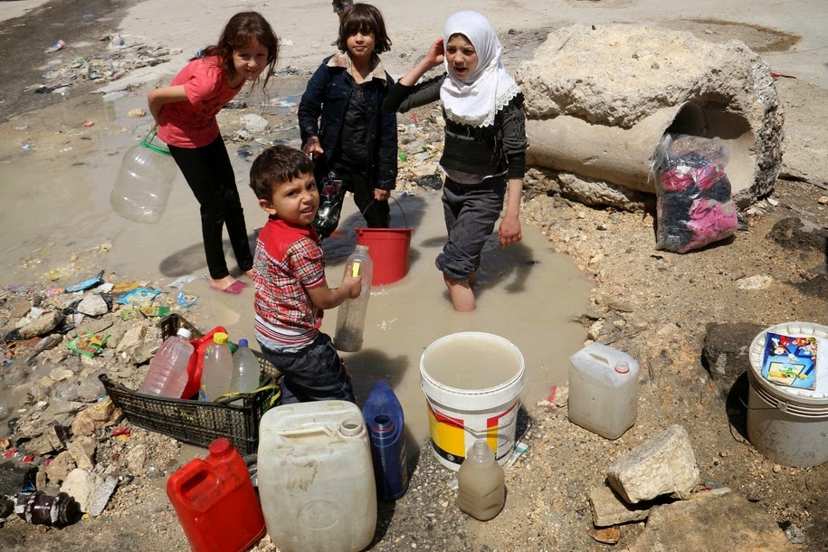
But there’s a lot more happening to explain why behind the veil of a quest for an Islamic State (IS), there’s also a war for water in Syria and Iraq. Making the plight of citizens worse is the continued targeting of water supply networks by both regime and opposition forces, which have attacked strategic lifelines, such as water channels, to gain control of territory and to punish and put pressure on their opponents.

Opening the flood gates …

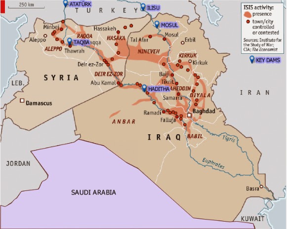
The Islamic State’s quest for hydrological control began in Syria, when it captured the Tabqa Dam in 2013. Rebel-held areas had been systematically denied electricity by President Bashar al-Assad’s forces in their effort to turn the population against the insurgency. The Tabqa Dam was built more than 40 years ago with Russian help and aimed to make Syria self-sufficient in energy production. Behind the dam is Lake Assad, which provides millions of Syrians with drinking water and is a vital irrigation source for farms. After the capture of the dam, IS opened the flood-gates to get maximum electricity supply for the areas they control and win favour with the local population. As a result, the lake dropped six metres, to a record low in May, which worsened the plight of millions of already destitute Syrians as severe water cuts began to hit Aleppo province.

Conflict over the water flowing though the Euphrates and Tigris is of course nothing new and predates religious wars. They were the first rivers to be used for large scale irrigation, in the region once known as the Fertile Crescent. Somewhere between 1720 and 1684 BC, a grandson of Hammurabi dammed the Tigris to prevent the retreat of rebels led by Iluma-Ilum, who declared the independence of Babylon. The Euphrates was already used as a weapon somewhere around 2500 BC, in another fight for Babylon, when the king of Umma cut the banks of irrigation canals alongside the Euphrates dug by his neighbor, the king of Girsu.

The Euphrates and Tigris are the two major and longest rivers in the Middle East. They both originate in Turkey. The Euphrates flows through Syria and Iraq to reach the Persian Gulf while the Tigris flows through Kurdish territory, meeting up with the Euphrates in the Southern Mesopotamian Marshes of Iraq. There are currently at least 46 dams in the Tigris-Euphrates basin, with at least 8 more planned or under construction. These dams have become key pieces of geo-political control in the region.

… and shutting down the flows

While one act of war is opening the flood gates, another is closing them. In 1974, Iraq threatened to bomb the same Tabqa Dam in Syria, alleging that the dam had reduced the flow of Euphrates River water to Iraq. But between then and now, Turkey, through its position upstream, has taken over as the most powerful regional commander of water, by completing the giant Ataturk Dam. In 1990 Syria and Iraq protested that Turkey now has a weapon of war: by closing the gates they could leave them dry. They had good reason to protest. In mid-1990 Turkish president Turgut Özal threatened to restrict water flow to Syria to force it to withdraw support for Kurdish rebels operating in southern Turkey.

In April 2014, the Islamic State blamed the low water levels in Lake Assad to Turkey’s closure of the Ataturk Dam. Sources found by Al Jazeera said that these claims are disputed. But even if the allegations are only partly true: they were used by the Islamic State to issue threats to ‘liberate Istanbul’, if that was necessary. So while Turkey, IS and Assad fight over water, millions of ordinary Syrians and Iraqi’s see their water levels drop dramatically. Not just by a new drought, with rainfall down by 50-85 percent since October 2013, but mostly due to a power struggle.

Tensions over water control in the region are set to heat up further if Turkey completes the Ilisu Dam on the Tigris River near the border of Syria. The Ilisu Dam will generate 1,200 MW and is part of the vast and ambitious Southeastern Anatolia Project, known as GAP after its Turkish title (Guneydogu Anadolu Projesi): a network comprising 22 dams and 19 power plants. The Ilisu reservoir will flood 52 villages and 15 towns, including Hasankeyf, a Kurdish town of 5,500 people, which is the only town in Anatolia that has survived since the Middle Ages and is under archaeological protection. It will displace approximately 16,000 people in the troubled Kurdish region.

The World Bank (WB), the British construction company Balfour Beatty and the Italian company Impreglio have all withdrawn from the problematic project. So have international funds and export credit from Austria, Germany and Switzerland. However, the project is currently funded by Turkish banks. Iraq and also Syria will be the most heavily impacted if the dam and others go through, with the most extreme projections holding that, owing to a combination of climate change and upstream dam activity, the Tigris and Euphrates rivers won’t have sufficient flow to reach the sea by as early as 2040.

If you live in Syria or Iraq and the water irrigating your field stops coming you might join the ranks of any army promising to attack those who kept the water for themselves – no matter if they tell you the truth or not. As is often the case in conflicts or epidemics it is not the facts themselves that count most but what people believe to be the facts. Those who can convince it’s the enemies fault that there’s not enough water will have the key to where the hearts and minds of the people will go to – no matter what the facts are.

The US finally finds a Weapon of Mass Destruction in Iraq

The Tabqa Dam is not the only dam attacked by IS. They are also trying to take the Haditha Dam, the second-largest in Iraq, raising the possibility of catastrophic damage and flooding. On Sunday, the US was bombing IS positions close to the dam. The IS militants are also fighting for control of the Euphrates River Dam, about 120 miles northwest of Baghdad and government forces were fighting to halt their advance. Insurgents from IS seized the Falluja Dam in Iraq in February and closed the floodgates to cause upstream flooding and to cut downstream water supply. Some 40.000 people were displaced just to flood the area around the city of Falluja to force government troops to retreat and lift a siege, while cutting water supplies and hydroelectricity generation for other parts of the country. All that was peanuts compared to what IS did next.

On August 7 IS captured the 1GW Mosul Dam on the Tigris – sending shock waves through Bagdad, Kuwait and the US. Whoever controls the Mosul Dam, the largest in Iraq, controls most of the country’s water and power resources. Located on the Tigris River upstream of Mosul, the dam, 3.6 km long and with 320 MW of capacity daily, formerly known as the Saddam dam, was built beginning in 1980 at a cost of 1.5$ billion USD, to bolster the regime during the Iran-Iraq war by a German-Italian consortium that was led by Hochtief Aktiengesellschaft. Its construction submerged many archaeological sites in the region yet more troubling is that because the dam was constructed on a foundation of soluble gypsum, it requires continuous grouting of the dam’s foundation to promote stability. Due to the engineering problems it presents it has been described recently by US engineers as “the most dangerous dam in the world.” And that was before the “most dangerous terror group ever” captured it.

A senior U.S. administration official said that “The failure of the Mosul Dam could threaten the lives of large numbers of civilians, threaten U.S. personnel and facilities – including the U.S. Embassy in Baghdad – and prevent the Iraqi government from providing critical services to the Iraqi populace,” (Source: Reuters). A 2006 U.S. Army Corps of Engineers report obtained by the Washington Post said the dam, which blocks the Tigris and holds 12 billion cubic meters of water, could flood two cities killing over a half a million people if it were destroyed or collapsed. The tsunami going to Mosul, a city of 1.7 million people, can be 20m high if the dam breaks with a full reservoir.

But even without a catastrophic failure, the dam is already at the epicenter of the war. Soon after the Islamic State captured the Mosul Dam they cut supplies to some villages in the north of the country that have not joined their cause. Recapturing this instrument of war was a sufficient reason for US forced to deploy air power to support Kurdish forces to recapture the dam. Saving the Yazidis from their mountain captured most media attention, but a key reason for the US to bomb Iraqi soil for the first time since 2011 was the fact that IS took the Mosul Dam. After bombing IS positions for several days, freshly re-equipped Kurdish fighters recently regained control of the dam.

Mega Dams & Water Management Practices

The importance of hydro-infrastructure in these battles and how it can be wielded firstly underlines the need for a serious re-appraisal of water management practices. Big dams (with funding from Multilateral agencies such as the WB, national and regional development banks, private equity and pension funds as well as from the Clean Development Mechanism, etc.) cause large scale displacement of populations, are ecologically destructive, wash away any other source of livelihood, and often saddle countries with debt while performing well below planned outputs as regards electricity generation. Moreover, compounded by climate change, contemporary ecological crises are leading to ever more conflict over trans-boundary water rights, such as for example between Ethiopia and Egypt, which are also on the verge of war over the construction of the Grand Renaissance and Gibe 3 dams, which would become Africa’s tallest. The world’s Big Dam Fan Club should take note of what has just happened in Syria and Iraq and realise that once disaster hits, hatred will not go to any God but to those who constructed the weapon of mass destruction. Water, rather than oil, is shaping up to be the key strategic resource in the region. More


Thursday, November 20, 2014

Wells Dry, Fertile Plains Turn to Dust

HASKELL COUNTY, Kan. — Forty-nine years ago, Ashley Yost’s grandfather sank a well deep into a half-mile square of rich Kansas farmland. He struck an artery of water so prodigious that he could pump 1,600 gallons to the surface every minute.

Last year, Mr. Yost was coaxing just 300 gallons from the earth, and pumping up sand in order to do it. By harvest time, the grit had robbed him of $20,000 worth of pumps and any hope of returning to the bumper harvests of years past.

“That’s prime land,” he said not long ago, gesturing from his pickup at the stubby remains of last year’s crop. “I’ve raised 294 bushels of corn an acre there before, with water and the Lord’s help.” Now, he said, “it’s over.”

The land, known as Section 35, sits atop the High Plains Aquifer, a waterlogged jumble of sand, clay and gravel that begins beneath Wyoming and South Dakota and stretches clear to the Texas Panhandle. The aquifer’s northern reaches still hold enough water in many places to last hundreds of years. But as one heads south, it is increasingly tapped out, drained by ever more intensive farming and, lately, by drought.

Vast stretches of Texas farmland lying over the aquifer no longer support irrigation. In west-central Kansas, up to a fifth of the irrigated farmland along a 100-mile swath of the aquifer has already gone dry. In many other places, there no longer is enough water to supply farmers’ peak needs during Kansas’ scorching summers.

And when the groundwater runs out, it is gone for good. Refilling the aquifer would require hundreds, if not thousands, of years of rains.

This is in many ways a slow-motion crisis — decades in the making, imminent for some, years or decades away for others, hitting one farm but leaving an adjacent one untouched. But across the rolling plains and tarmac-flat farmland near the Kansas-Colorado border, the effects of depletion are evident everywhere. Highway bridges span arid stream beds. Most of the creeks and rivers that once veined the land have dried up as 60 years of pumping have pulled groundwater levels down by scores and even hundreds of feet.

On some farms, big center-pivot irrigators — the spindly rigs that create the emerald circles of cropland familiar to anyone flying over the region — now are watering only a half-circle. On others, they sit idle altogether.

Two years of extreme drought, during which farmers relied almost completely on groundwater, have brought the seriousness of the problem home. In 2011 and 2012, the Kansas Geological Survey reports, the average water level in the state’s portion of the aquifer dropped 4.25 feet — nearly a third of the total decline since 1996.

And that is merely the average. “I know my staff went out and re-measured a couple of wells because they couldn’t believe it,” said Lane Letourneau, a manager at the State Agriculture Department’s water resources division. “There was a 30-foot decline.”

Kansas agriculture will survive the slow draining of the aquifer — even now, less than a fifth of the state’s farmland is irrigated in any given year — but the economic impact nevertheless will be outsized. In the last federal agriculture census of Kansas, in 2007, an average acre of irrigated land produced nearly twice as many bushels of corn, two-thirds more soybeans and three-fifths more wheat than did dry land.

Farmers will take a hit as well. Raising crops without irrigation is far cheaper, but yields are far lower. Drought is a constant threat: the last two dry-land harvests were all but wiped out by poor rains.

In the end, most farmers will adapt to farming without water, said Bill Golden, an agriculture economist at Kansas State University. “The revenue losses are there,” he said. “But they’re not as tremendously significant as one might think.”

Some already are. A few miles west of Mr. Yost’s farm, Nathan Kells cut back on irrigation when his wells began faltering in the last decade, and shifted his focus to raising dairy heifers — 9,000 on that farm, and thousands more elsewhere. At about 12 gallons a day for a single cow, Mr. Kells can sustain his herd with less water than it takes to grow a single circle of corn.

“The water’s going to flow to where it’s most valuable, whether it be industry or cities or feed yards,” he said. “We said, ‘What’s the higher use of the water?’ and decided that it was the heifer operation.”

The problem, others say, is that when irrigation ends, so do the jobs and added income that sustain rural communities.

“Looking at areas of Texas where the groundwater has really dropped, those towns are just a shell of what they once were,” said Jim Butler, a hydrogeologist and senior scientist at the Kansas Geological Survey.

The villain in this story is in fact the farmers’ savior: the center-pivot irrigator, a quarter- or half-mile of pipe that traces a watery circle around a point in the middle of a field. The center pivots helped start a revolution that raised farming from hardscrabble work to a profitable business.

Since the pivots’ debut some six decades ago, the amount of irrigated cropland in Kansas has grown to nearly three million acres, from a mere 250,000 in 1950. But the pivot irrigators’ thirst for water — hundreds and sometimes thousands of gallons a minute — has sent much of the aquifer on a relentless decline. And while the big pivots have become much more efficient, a University of California study earlier this year concluded that Kansas farmers were using some of their water savings to expand irrigation or grow thirstier crops, not to reduce consumption.

A shift to growing corn, a much thirstier crop than most, has only worsened matters. Driven by demand, speculation and a government mandate to produce biofuels, the price of corn has tripled since 2002, and Kansas farmers have responded by increasing the acreage of irrigated cornfields by nearly a fifth.

At an average 14 inches per acre in a growing season, a corn crop soaks up groundwater like a sponge — in 2010, the State Agriculture Department said, enough to fill a space a mile square and nearly 2,100 feet high.

Sorghum, or milo, gets by on a third less water, Kansas State University researchers say — and it, too, is in demand by biofuel makers. As Kansas’ wells peter out, more farmers are switching to growing milo on dry land or with a comparative sprinkle of irrigation water.

But as long as there is enough water, most farmers will favor corn. “The issue that often drives this is economics,” said David W. Hyndman, who heads Michigan State University’s geological sciences department. “And as long as you’ve got corn that’s $7, then a lot of choices get made on that.”

Of the 800 acres that Ashley Yost farmed last year in Haskell County, about 70 percent was planted in corn, including roughly 125 acres in Section 35. Haskell County’s feedlots — the county is home to 415,000 head of cattle — and ethanol plants in nearby Liberal and Garden City have driven up the price of corn handsomely, he said.

But this year he will grow milo in that section, and hope that by ratcheting down the speed of his pump, he will draw less sand, even if that means less water, too. The economics of irrigation, he said, almost dictate it.

“You’ve got $20,000 of underground pipe,” he said. “You’ve got a $10,000 gas line. You’ve got a $10,000 irrigation motor. You’ve got an $89,000 pivot. And you’re going to let it sit there and rot?

“If you can pump 150 gallons, that’s 150 gallons Mother Nature is not giving us. And if you can keep a milo crop alive, you’re going to do it.”

Mr. Yost’s neighbors have met the prospect of dwindling water in starkly different ways. A brother is farming on pivot half-circles. A brother-in-law moved most of his operations to Iowa. Another farmer is suing his neighbors, accusing them of poaching water from his slice of the aquifer.

A fourth grows corn with an underground irrigation system that does not match the yields of water-wasting center-pivot rigs, but is far thriftier in terms of water use and operating costs.

For his part, Mr. Yost continues to pump. But he also allowed that the day may come when sustaining what is left of the aquifer is preferable to pumping as much as possible.

Sitting in his Ford pickup next to Section 35, he unfolded a sheet of white paper that tracked the decline of his grandfather’s well: from 1,600 gallons a minute in 1964, to 1,200 in 1975, to 750 in 1976.

When the well slumped to 500 gallons in 1991, the Yosts capped it and drilled another nearby. Its output sank, too, from 1,352 gallons to 300 today.

This year, Mr. Yost spent more than $15,000 to drill four test wells in Section 35. The best of them produced 195 gallons a minute — a warning, he said, that looking further for an isolated pocket of water would be costly and probably futile.

“We’re on the last kick,” he said. “The bulk water is gone.” More


Sunday, September 7, 2014

Drought apocalypse begins in California as wells run dry

(NaturalNews) Water wells in central California have begun to run dry, reports the LA Times. (1) "Extreme drought conditions have become so harsh for the Central Valley community of East Porterville [that] many of its residents dependent on their own wells have run out of water."

Tulare County has confirmed their wells have run out of water, and so far hundreds of homes have no running water.

According to the LA Times, rumors are also spreading that Child Protective Services officials will begin taking children away from families who have no running water, although the county claims the rumor is false.

It begins: the collapse of California's water aquifers

With this news, it is now official that the collapse of California's water aquifers has begun. With each passing month and year, more and more wells will run dry across the state as California plummets into the desert conditions from which it once sprang.

Extreme drought now covers 82% of California, according to the National Drought Mitigation Center. (2) Fifty-eight percent of the state is in "exceptional drought."

During the unfolding of this drought, California farmers and cities have siphoned unprecedented volumes of water out of the state's underground aquifers. This is called "fossil water" and it can take centuries to regenerate. Once this fossil water is used up, it's gone.

35-year "megadrought" may be on the way

"The southwestern United States has fifty percent change of suffering a 'megadrought' that lasts 35 years," reports the Daily Mail. (3)

"They say global warming has meant the chance of a decade long drought is at least 50 percent, and the chances of a 'megadrought' – one that lasts up to 35 years – ranges from 20 to 50 percent over the next century."

One scientist is quoted in the story as saying, "This will be worse than anything seen during the last 2,000 years and would pose unprecedented challenges to water resources in the region."

Unless politicians become magical wizards and figure out a way to create water out of nothing, what all this really means is that cities of the American southwest will not be able to support present-day populations. A mass migration (evacuation) out of the cities will be necessary sooner or later.

California's water deficit will lead to ecological and economic collapse

In an almost perfect reflection of California's state budget deficits, the state is also running an unsustainable water deficit. It is a mathematical certainty that when you remove far more water from the aquifers than is being replenished, the amount of water remaining in those aquifers will eventually reach zero.

This "zero day" water reality is still psychologically denied by most Californians. If the reality of this situation were widely recognized, California would be experiencing a glut of real estate inventory as millions of homeowners tried to sell their properties and evacuate the state. The fact that the real estate market has not yet collapsed in California tells us that Californians are still living in a state of denial about the future of their water supply.

Even as California's water supply collapses by the day, local farmers and towns have few options other than drilling for more water. "Drill! Drill! Drill!" is the mantra of the day, creating an 18-month backlog for well drilling companies. Each new well that's drilled must seek to go deeper than the previous wells which are running dry. It's a literal race to the bottom which can only end in catastrophe.

Then again, a willful acceleration toward catastrophe is merely a sign of the times when it comes to human civilization. There is almost no area in which humans have ever achieved balance: not in fossil fuels, metals mining, fossil water exploitation, debt creation, industrial chemical contamination, ecological exploitation or even global population. It's almost as if the human race is determined to destroy itself while racing to see who can achieve self destruction first. More


Saturday, August 23, 2014

How extensive is California's drought?

A snake-like trickle of water flows underneath Lake Oroville's Enterprise Bridge — just one striking example of how much California's chronic drought is affecting the state's lakes and reservoirs.

Situated at the foot of the Sierra Nevadas in Butte County, Lake Oroville is one of the largest reservoirs in California, second only to Shasta Lake. After enduring three straight years of drought, the lake is currently only filled to 32 percent of its capacity.

In any case, the drought in California is getting serious. Phase 2 of Los Angeles' mandatory water conservation ordinance is now in effect, which means a team of water-use inspectors are tasked with enforcing water restrictions and fining water wasters. If the drought continues through fall and winter, the ordinance will move to Phase 3, which entails even stricter rules and some prohibitions.

To get a better idea of the dire situation in the Golden State, continue below for a photo comparison of water levels taken in 2011 and 2014, looking at Lake Oroville and Folsom Lake, another major California reservoir located in Sacramento County that is now filled at 40 percent of its capacity.

Bidwell Marina, Lake Oroville

Folsam Dam, Folsom Lake

Enterprise Bridge, Lake Oroville


Sunday, August 17, 2014

China Suffers Drought, Water Shortage

This summer has been one of the hottest in decades in Jilin Province, China, and several counties are facing the complete loss of their harvests.

Currently, Changling, Nongan, Gongzhuling and 10 other agricultural counties in Jilin are facing a severe drought. The severity of the drought is comparable to that in 1951.

A villager Ms. Lee from Wanglong village, Huajia Township, Nongan County, Changhun City, told Epoch Times: “The drought is very bad. All the corn leaves have turned yellow. Corns are not fully grown, only their tips are seen with barely any kernels.”

Since July 1 this year, the rainfall in Jilin Province totaled only 4.4 inches, which is about 48 percent less compared to the same period from previous years. This year had the second lowest rainfall in history; the least amount since 1951.

Over 14 million acres of farmland are affected.

Government data indicates the drought has impacted more than 1.3 million acres of farmland in the major agricultural areas of Jilin with no improvements in sight. According to the weather forecast, the average rainfall could be as low as a third of an inch per day.

Ms. Lee, a villager from Wanglong village said: “Even the water level of our own well is slowly dropping. It is only enough for domestic use. Our farmland has not been irrigated for over a month.”

Mr. Sun from Zhen-Chai village, Nongan County said that all their cucumber plants have perished from the drought.

Chinese media has reported two-thirds of the corn stalks have withered in some towns while others have completely perished.

Local governments have not taken any measure to tackle this problem and villagers are on their own. A staff member at Jilin Grain Bureau only briefly told Epoch Times that the situation was “unclear” and then hung up the phone.

Other Provinces Impacted

During the summer, a total of 12 provinces, including Shandong, Henan, Shaanxi Anhui, Hubei, Gangsu, and Xinjiang, have been affected by the drought. Over 14 million acres of farmland are affected.

Henan Province, for example, is witnessing the worst drought in the last 63 year with 740,000 people facing a temporary shortage of drinking water. In Shandong Province the cost of the lost harvest is reaching $630 million.

All these statistics put into question the recently announced food exports to Russia. After Russia announced it would stop importing food from Europe, the United States, and Australia, China immediately started building a warehouse on the Russian boarder to facilitate customs clearance for fruit going into Russia. More


Friday, August 1, 2014

'There Will Be No Water' by 2040? Researchers Urge Global Energy Paradigm Shift

The world risks an "insurmountable" water crisis by 2040 without an immediate and significant overhaul of energy consumption and demand, a research team reported on Wednesday.

"There will be no water by 2040 if we keep doing what we're doing today," said Professor Benjamin Sovacool of Denmark's Aarhus University, who co-authored two reports on the world's rapidly decreasing sources of freshwater.

Many troubling global trends could worsen these baseline projected shortages. According to the report, water resources around the world are "increasingly strained by economic development, population growth, and climate change." The World Resources Institute estimates that in India, "water demand will outstrip supply by as much as 50 percent by 2030, a situation worsened further by the country's likely decline of available freshwater due to climate change," the report states. "[P]ower demand could more than double in northern China, more than triple in India, and increase by almost three-quarters in Texas."

"If we keep doing business as usual, we are facing an insurmountable water shortage — even if water was free, because it's not a matter of the price," Sovacool said. "There's no time to waste. We need to act now."

In addition to an expanding global population, economic development, and an increasing demand for energy, the report also finds that the generation of electricity is one of the biggest sources of water consumption throughout the world, using up more water than even the agricultural industry. Unlike less water-intensive alternative sources of energy like wind and solar systems, fossil fuel-powered and nuclear plants need enormous and continued water inputs to function, both for fueling thermal generators and cooling cycles.

The reports, Capturing Synergies Between Water Conservation and Carbon Dioxide Emissions in the Power Sectorand A Clash of Competing Necessities: Water Adequacy and Electric Reliability in China, India, France, and Texas and published after three years of research by Aarhus University, Vermont Law School and CNA Corporation, show that most power plants do not even log how much water they use to keep the systems going.

"It's a huge problem that the electricity sector do not even realize how much water they actually consume," Sovacool said. "And together with the fact that we do not have unlimited water resources, it could lead to a serious crisis if nobody acts on it soon."

Unless water use is drastically minimized, the researchers found that widespread drought will affect between 30 and 40 percent of the planet by 2020, and another two decades after that will see a severe water shortage that would affect the entire planet. The demand for both energy and drinking water would combine to aggressively speed up drought, which in turn could exacerbate large-scale health risks and other global development problems.

"The policy and technology choices made to meet demand will have immense implications for water withdrawals and consumption, and may also have significant economic, human health, and development consequences," the report states.

The research says that utilizing alternative energy sources like wind and solar systems is vital to mitigating water consumption enough to stave off the crisis. "Unsubsidized wind power costs... are currently lower than coal or nuclear and they are continuing to drop," the report states. When faced with its worst drought in 2011, Texas got up to 18 of its electricity from wind power and was able to avoid the kind of rolling blackouts that plague parts of China, where existing water shortages prevent power plants from operating.

An equally important step would be to shutter "thirsty" fossil fuel facilities in areas that are already experiencing water shortages, like China and India, where carbon emissions can be significantly more impactful.

"[We] have to decide where we spend our water in the future," Sovacool said. "Do we want to spend it on keeping the power plants going or as drinking water? We don't have enough water to do both." More


Saturday, May 31, 2014

Monsoon Disrupted By El Nino + Climate Change as India Suffers Deaths, Crop Losses from Extreme Heat.

May is the month when the massive rainstorm that is the Asian Monsoon begins to gather and advance. This year, as in many other years, the monsoon gradually formed along the coast of Myanmar early in the month. It sprang forward with gusto reaching the Bay of Bengal by last week.

And there it has stalled ever since.

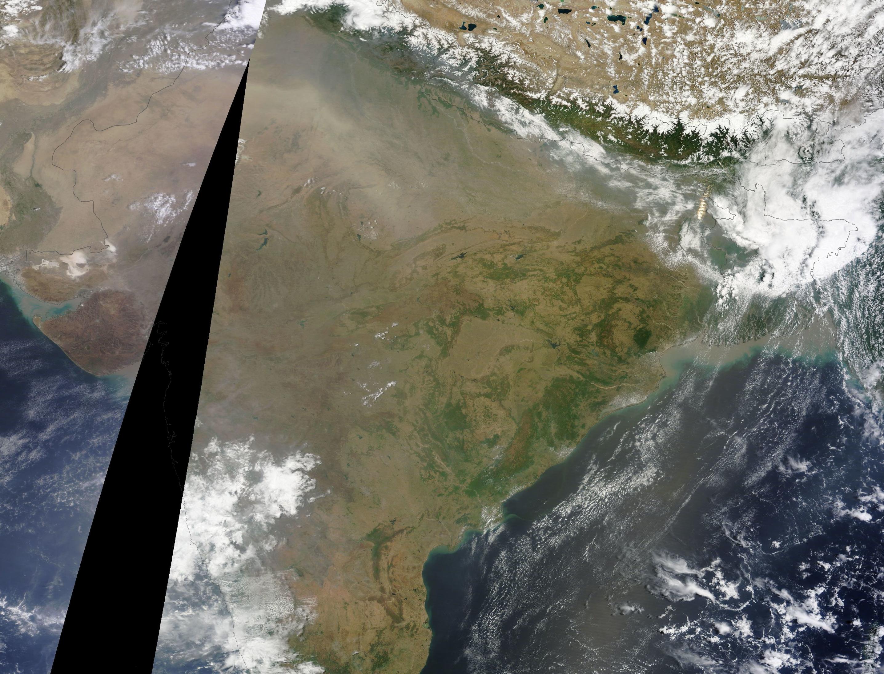
On May 25-27, an outburst of moisture from this stalled monsoonal flow splashed over the coasts of India. But by the 29th and 30th, these coastal storms and even the ones gathering over the Bengali waters had all been snuffed out. The most prominent feature in the MODIS shot of India today isn’t the rainfall that should be now arriving along the southeast coast, but the thick and steely-gray pallor of coal-ash smog trapped under a persistent and oppressive dome of intense heat.

(MODIS shot of India on May 30th. See the open stretch of blue water in the lower right frame? That’s the Bay of Bengal which borders coastal India. During a normal year at this time, that entire ocean zone should be filled with the storm clouds of a building monsoon that is already encroaching on coastal India. Today, there is nothing but a smattering of small and dispersed cloud through a mostly clear sky. Image source: LANCE-MODIS.)

Monsoon Described as Feeble

Official forecasts had already announced as of May 27th that the annual monsoon was likely to be delayed by at least a week for southeast regions of India. Meanwhile, expected monsoonal rainfall for western and northern sections of India for 2014 fell increasingly into doubt.

From The Times of India:

The monsoon is likely to be delayed by 10 days, according to scientists at the Indian Institute of Tropical Meteorology (IITM) here. The IITM’s third experimental real-time forecast says that a feeble monsoon will reach central India after June 20 as against the usual June 15. Last year, the monsoon had covered the entire country by June 15.

The annual monsoon is key to India’s agriculture. The substantial rains nurture crops even as they tamp down a powerful heating that typically builds throughout the sub-continent into early summer. Without these rains, both heat and drought tend to run rampant, bringing down crop yields and resulting in severe human losses due to excessive heat.

But, this year, heat and drought are already at extreme levels.

Major Heatwave Already Results in Loss of Life for 2014

As early as late March, the heatwave began to build over the Indian subcontinent. The heat surged throughout the state, setting off fires, resulting in a growing list of heat casualties, shutting down the power grid and spurring unrest. Meanwhile, impacts to India’s agriculture were already growing as the Lychee fruit crop was reported to have suffered a 40% loss.

By late May, temperatures across a broad region had surged above 105 degrees shattering records as the oppressive and deadly heat continued to tighten its grip.

In a country surrounded on three sides by oceans, it is a combination of heat, humidity and persistently high night-time temperatures that can be a killer. Wet bulb temperatures surge into a high-risk range for human mortality during the day even as night-time provides little respite for already stressed human bodies. Such extreme and long-duration heat doesn’t come without a sad toll. As of today, early reports indicated a loss of more than 56 lives due to heat stroke (In 2012 and 2013, total Indian heat deaths were near 1,000 each year). That said, final figures on heat losses are still pending awaiting complete reports from all of India’s provinces.

"Climatologically, we know that heatwaves are increasing in frequency and the number of days exceeding 45ºC temperatures is increasing. The frequency will increase further with global warming, hence this is a good example of a situation where science and disaster management can come together and avert damage," a spokesman for India’s National Disaster Management Authority noted on Friday.

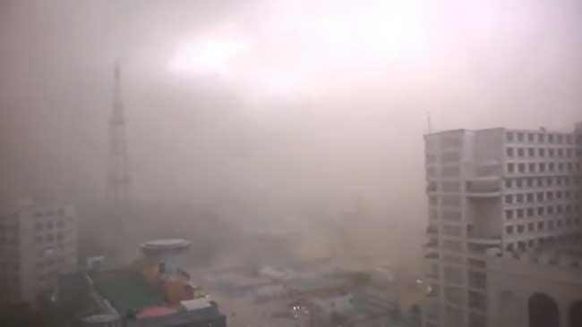
(Hot Dust. A dust storm rolls through New Delhi on Friday amidst furnace-like 113 degree heat snarling traffic and resulting in the tragic loss of 9 more lives. Image source: Gaurav Karoliwal/YouTube Screenshot.)

Today the heatwave continued to gain ground, with Kota and Rajasthan reaching an all-time record of 116 degree F (46.5 C) as New Delhi’s mercury hit 113 degrees F in the midst of a drought-induced dust storm. Dust shrouding the city spurred traffic chaos and in the heat, darkness, and confusion nine more souls were lost.

After two months of growing disruption due to heat and drought, the lands and peoples of India cry out for a Monsoon that is running later and later with each new weather report.

Climate Change + El Nino: Adding Heat and Beating Back the Monsoon

As systems approach tipping points, they are more likely to tilt toward the extremes.

For India this year, its seasonally warmest period from April to May found severe heat amplification from a number of global factors. First, climate change seeded the ground for the current Indian heatwave by adding general heat and evaporation to already hot conditions. With global average heating of +0.8 C above 1880s levels amplifying in the hot zones, early moisture loss due to higher-than-normal temperatures produces a kind of snowball effect for still more warming. Essentially, the cooling effect of water evaporation is baked out early allowing for heat to hit harder just as typical seasonal maximums are reached. More

Originally published by robertscribbler.wordpress.com/


Monday, May 19, 2014

The California Drought Is Far From Over, And The Entire State Is Suffering

For a few days last month, it rained in San Francisco. Residents across the city cheered a welcomed respite from a drought that has crippled California for more than two years -- but the celebration turned out to be premature.

On Thursday, for the first time this century, the U.S. Drought Monitor declared that all of California is in a “severe” drought, with many areas of the state in an even worse condition, from "extreme" to "exceptional," the poorest possible rating.

“This is a once-in-a-generation conversation,” Mark Svoboda, a climatologist at the National Drought Mitigation Center, told The Huffington Post. He added that the last time California experienced comparable conditions was in the mid-1970s.

“The state has doubled its population between then and now,” Svoboda said. “You’ve got a lot more people using a relatively finite amount of water.”

The map below, courtesy of the U.S. Drought Monitor, shows the varying levels of drought throughout California. The orange represents “severe,” the red is “extreme,” and the maroon is “exceptional” -- the agency’s highest level (Story continues below):

No area of the state is feeling the effects of the drought more harshly than San Diego, where wildfires have ripped through more than 10,000 acres of land and tens of thousands of residents have been forced to evacuate. “In a drought, the biggest threat to health and human safety is wildfire,” Doug Carlson, an information officer at the California Department of Water Resources, told HuffPost.

And there doesn’t appear to be an end in sight. “The drought has set the stage for a very busy, very long, potentially very dangerous fire season,” Daniel Berlant, a spokesperson for CAL FIRE, said to HuffPost. “As we move into the more traditional summer months, the days are only going to get longer, and the temperatures are only going to get higher.”

California’s wildfire season usually peaks during summer and fall months and then tapers during the typically rainy winter. But the drought has turned wildfires into a year-round issue. “With that lack of rain, the grass, brush and trees really have been tinder-dry all year long,” Berlant explained, noting such conditions help flames flourish.

Svoboda added that the state’s hot, dry surface leads to a hot, dry, atmosphere, which creates a prime environment for wildfires to spread. “You also typically see windier conditions,” he added. “These are all things that fires feed on.”

The damage in Southern California has ravaged hills, homes and businesses. Beloved craft brewery Stone Brewing Company evacuated its premises on Thursday. On Wednesday, KTLA senior producer Marcus Smith tweeted a widely-recirculated photo of a “firenado,” a dangerous phenomenon caused by strong winds whipping spirals of fire into the air. More